You are here: Home > Network List > TA - USArray Transportable Network (new EarthScope stations) Stations List
> Station M15A Larsen Ranch, Promontory, UT, USA > Earthquake Result Viewer
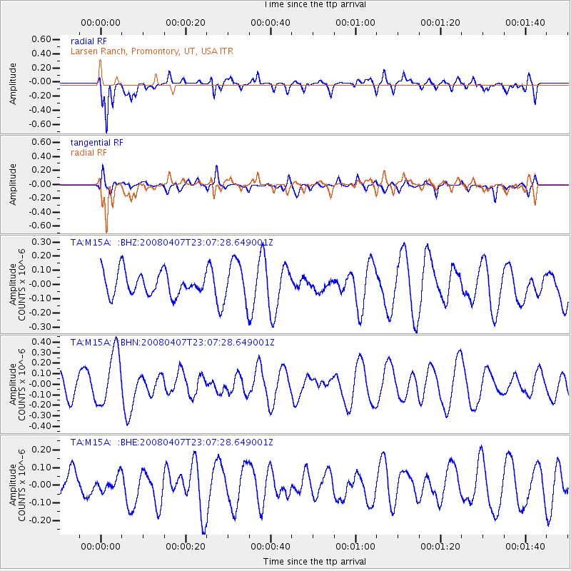
M15A Larsen Ranch, Promontory, UT, USA - Earthquake Result Viewer
*The percent match for this event was below the threshold and hence no stack was calculated.
| Earthquake location: |
Vanuatu Islands |
| Earthquake latitude/longitude: |
-20.0/168.5 |
| Earthquake time(UTC): |
2008/04/07 (098) 22:54:36 GMT |
| Earthquake Depth: |
10 km |
| Earthquake Magnitude: |
5.5 MB, 5.5 MS, 5.8 MW, 5.7 MW |
| Earthquake Catalog/Contributor: |
WHDF/NEIC |
|
| Network: |
TA USArray Transportable Network (new EarthScope stations) |
| Station: |
M15A Larsen Ranch, Promontory, UT, USA |
| Lat/Lon: |
41.46 N/112.45 W |
| Elevation: |
1348 m |
|
| Distance: |
95.2 deg |
| Az: |
47.821 deg |
| Baz: |
248.04 deg |
| Ray Param: |
$rayparam |
*The percent match for this event was below the threshold and hence was not used in the summary stack. |
|
| Radial Match: |
69.655495 % |
| Radial Bump: |
400 |
| Transverse Match: |
41.446262 % |
| Transverse Bump: |
400 |
| SOD ConfigId: |
2504 |
| Insert Time: |
2010-03-06 21:40:47.141 +0000 |
| GWidth: |
2.5 |
| Max Bumps: |
400 |
| Tol: |
0.001 |
|
Signal To Noise
| Channel | StoN | STA | LTA |
| TA:M15A: :BHN:20080407T23:07:28.649001Z | 3.3005333 | 2.604372E-7 | 7.890762E-8 |
| TA:M15A: :BHE:20080407T23:07:28.649001Z | 0.67575526 | 4.152941E-8 | 6.145629E-8 |
| TA:M15A: :BHZ:20080407T23:07:28.649001Z | 1.815872 | 1.4685197E-7 | 8.0871324E-8 |
| Arrivals |
| Ps | |
| PpPs | |
| PsPs/PpSs | |


