You are here: Home > Network List > GS - US Geological Survey Networks Stations List
> Station DEC05 Decatur Surface Seismic Site, Decatur, IL, USA > Earthquake Result Viewer
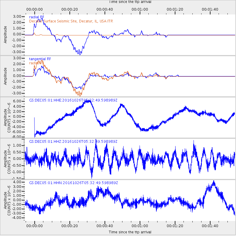
DEC05 Decatur Surface Seismic Site, Decatur, IL, USA - Earthquake Result Viewer
*The percent match for this event was below the threshold and hence no stack was calculated.
| Earthquake location: |
Tonga Islands |
| Earthquake latitude/longitude: |
-15.5/-174.9 |
| Earthquake time(UTC): |
2016/10/26 (300) 05:19:50 GMT |
| Earthquake Depth: |
10 km |
| Earthquake Magnitude: |
6.1 MWW, 6.1 MWC |
| Earthquake Catalog/Contributor: |
NEIC PDE/NEIC COMCAT |
|
| Network: |
GS US Geological Survey Networks |
| Station: |
DEC05 Decatur Surface Seismic Site, Decatur, IL, USA |
| Lat/Lon: |
39.87 N/88.87 W |
| Elevation: |
216 m |
|
| Distance: |
96.8 deg |
| Az: |
50.64 deg |
| Baz: |
255.551 deg |
| Ray Param: |
$rayparam |
*The percent match for this event was below the threshold and hence was not used in the summary stack. |
|
| Radial Match: |
9.074091 % |
| Radial Bump: |
400 |
| Transverse Match: |
8.842414 % |
| Transverse Bump: |
400 |
| SOD ConfigId: |
1815711 |
| Insert Time: |
2016-11-09 05:20:49.714 +0000 |
| GWidth: |
2.5 |
| Max Bumps: |
400 |
| Tol: |
0.001 |
|
Signal To Noise
| Channel | StoN | STA | LTA |
| GS:DEC05:01:HHZ:20161026T05:32:49.598989Z | 0.7645337 | 2.3841102E-7 | 3.1183848E-7 |
| GS:DEC05:01:HHN:20161026T05:32:49.598989Z | 2.3172362 | 2.9603948E-6 | 1.2775541E-6 |
| GS:DEC05:01:HHE:20161026T05:32:49.598989Z | 2.2750022 | 7.3995E-6 | 3.2525245E-6 |
| Arrivals |
| Ps | |
| PpPs | |
| PsPs/PpSs | |


