You are here: Home > Network List > IW - Intermountain West Stations List
> Station MOOW Moose Ponds, Wyoming, USA > Earthquake Result Viewer
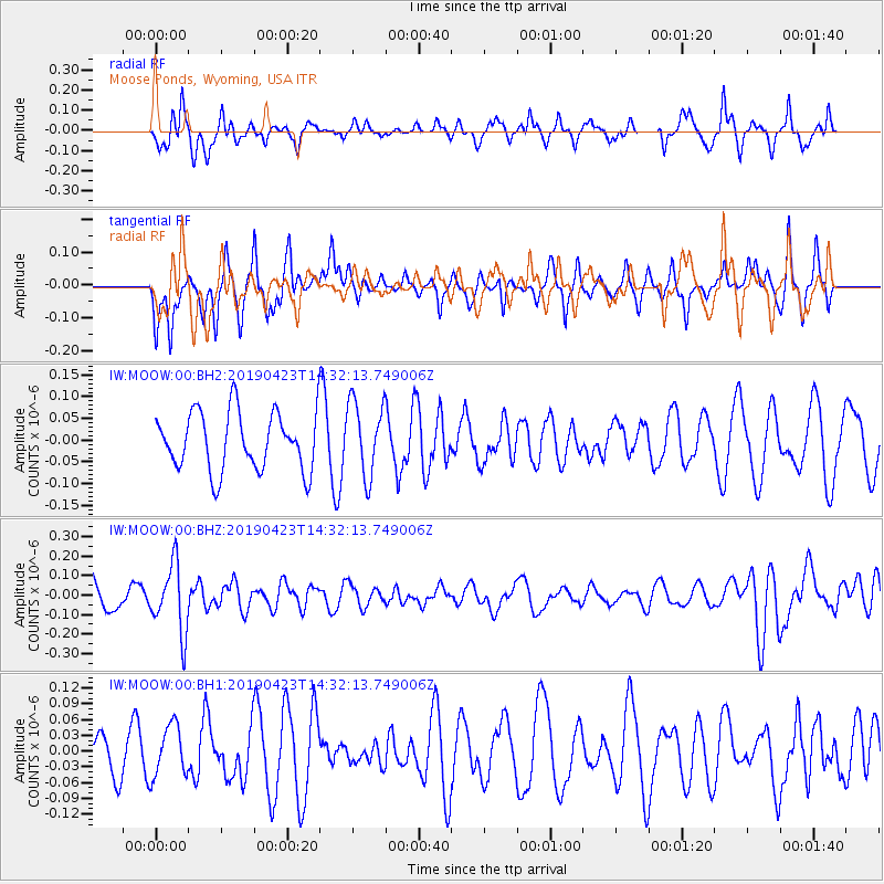
MOOW Moose Ponds, Wyoming, USA - Earthquake Result Viewer
*The percent match for this event was below the threshold and hence no stack was calculated.
| Earthquake location: |
South Of Fiji Islands |
| Earthquake latitude/longitude: |
-24.7/-178.8 |
| Earthquake time(UTC): |
2019/04/23 (113) 14:20:17 GMT |
| Earthquake Depth: |
386 km |
| Earthquake Magnitude: |
6.0 Mww |
| Earthquake Catalog/Contributor: |
NEIC PDE/us |
|
| Network: |
IW Intermountain West |
| Station: |
MOOW Moose Ponds, Wyoming, USA |
| Lat/Lon: |
43.75 N/110.74 W |
| Elevation: |
2128 m |
|
| Distance: |
92.3 deg |
| Az: |
42.264 deg |
| Baz: |
237.573 deg |
| Ray Param: |
$rayparam |
*The percent match for this event was below the threshold and hence was not used in the summary stack. |
|
| Radial Match: |
57.93553 % |
| Radial Bump: |
345 |
| Transverse Match: |
61.462944 % |
| Transverse Bump: |
369 |
| SOD ConfigId: |
18252611 |
| Insert Time: |
2019-05-07 14:23:56.109 +0000 |
| GWidth: |
2.5 |
| Max Bumps: |
400 |
| Tol: |
0.001 |
|
Signal To Noise
| Channel | StoN | STA | LTA |
| IW:MOOW:00:BHZ:20190423T14:32:13.749006Z | 1.7551464 | 1.7374563E-7 | 9.89921E-8 |
| IW:MOOW:00:BH1:20190423T14:32:13.749006Z | 0.897704 | 4.904874E-8 | 5.4637983E-8 |
| IW:MOOW:00:BH2:20190423T14:32:13.749006Z | 1.285374 | 8.59067E-8 | 6.683401E-8 |
| Arrivals |
| Ps | |
| PpPs | |
| PsPs/PpSs | |


