You are here: Home > Network List > TA - USArray Transportable Network (new EarthScope stations) Stations List
> Station T15A Red Dirt Ranch, Kanab, UT, USA > Earthquake Result Viewer
T15A Red Dirt Ranch, Kanab, UT, USA - Earthquake Result Viewer
| Earthquake location: |
Central East Pacific Rise |
| Earthquake latitude/longitude: |
-4.6/-106.0 |
| Earthquake time(UTC): |
2008/09/18 (262) 01:41:02 GMT |
| Earthquake Depth: |
10 km |
| Earthquake Magnitude: |
5.5 MB, 5.7 MS, 6.0 MW, 6.0 MW |
| Earthquake Catalog/Contributor: |
WHDF/NEIC |
|
| Network: |
TA USArray Transportable Network (new EarthScope stations) |
| Station: |
T15A Red Dirt Ranch, Kanab, UT, USA |
| Lat/Lon: |
37.02 N/112.38 W |
| Elevation: |
1561 m |
|
| Distance: |
41.8 deg |
| Az: |
352.327 deg |
| Baz: |
170.427 deg |
| Ray Param: |
0.0735721 |
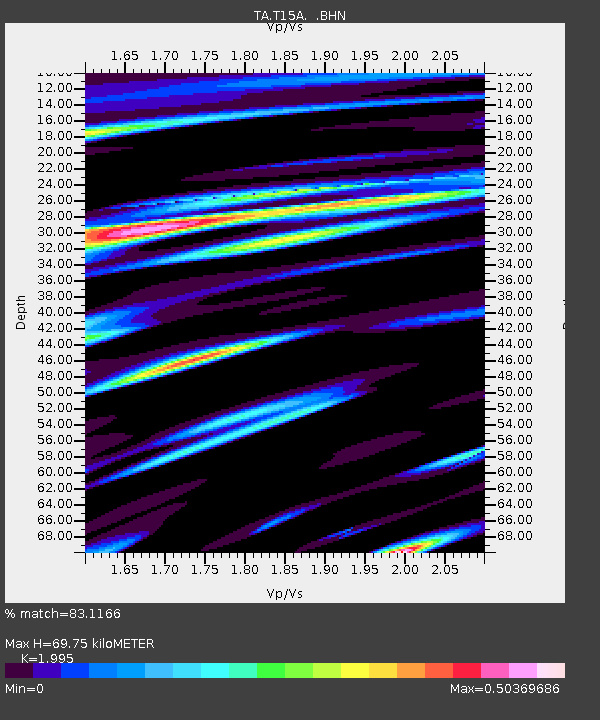
| Estimated Moho Depth: |
69.75 km |
| Estimated Crust Vp/Vs: |
2.00 |
| Assumed Crust Vp: |
6.194 km/s |
| Estimated Crust Vs: |
3.105 km/s |
| Estimated Crust Poisson's Ratio: |
0.33 |
|
| Radial Match: |
83.1166 % |
| Radial Bump: |
363 |
| Transverse Match: |
69.612114 % |
| Transverse Bump: |
400 |
| SOD ConfigId: |
2560 |
| Insert Time: |
2010-03-06 21:41:56.608 +0000 |
| GWidth: |
2.5 |
| Max Bumps: |
400 |
| Tol: |
0.001 |
|

Signal To Noise
| Channel | StoN | STA | LTA |
| TA:T15A: :BHN:20080918T01:48:21.500004Z | 3.837385 | 3.186601E-7 | 8.304095E-8 |
| TA:T15A: :BHE:20080918T01:48:21.500004Z | 1.9913739 | 1.2857922E-7 | 6.456809E-8 |
| TA:T15A: :BHZ:20080918T01:48:21.500004Z | 1.014321 | 4.837266E-8 | 4.76897E-8 |
| Arrivals |
| Ps | 12 SECOND |
| PpPs | 32 SECOND |
| PsPs/PpSs | 44 SECOND |


