You are here: Home > Network List > TA - USArray Transportable Network (new EarthScope stations) Stations List
> Station T15A Red Dirt Ranch, Kanab, UT, USA > Earthquake Result Viewer
T15A Red Dirt Ranch, Kanab, UT, USA - Earthquake Result Viewer
| Earthquake location: |
Andreanof Islands, Aleutian Is. |
| Earthquake latitude/longitude: |
51.4/-179.0 |
| Earthquake time(UTC): |
2007/12/21 (355) 07:24:34 GMT |
| Earthquake Depth: |
30 km |
| Earthquake Magnitude: |
6.1 MB, 6.2 MW, 6.3 ML |
| Earthquake Catalog/Contributor: |
WHDF/NEIC |
|
| Network: |
TA USArray Transportable Network (new EarthScope stations) |
| Station: |
T15A Red Dirt Ranch, Kanab, UT, USA |
| Lat/Lon: |
37.02 N/112.38 W |
| Elevation: |
1561 m |
|
| Distance: |
48.2 deg |
| Az: |
80.101 deg |
| Baz: |
309.492 deg |
| Ray Param: |
0.06945072 |
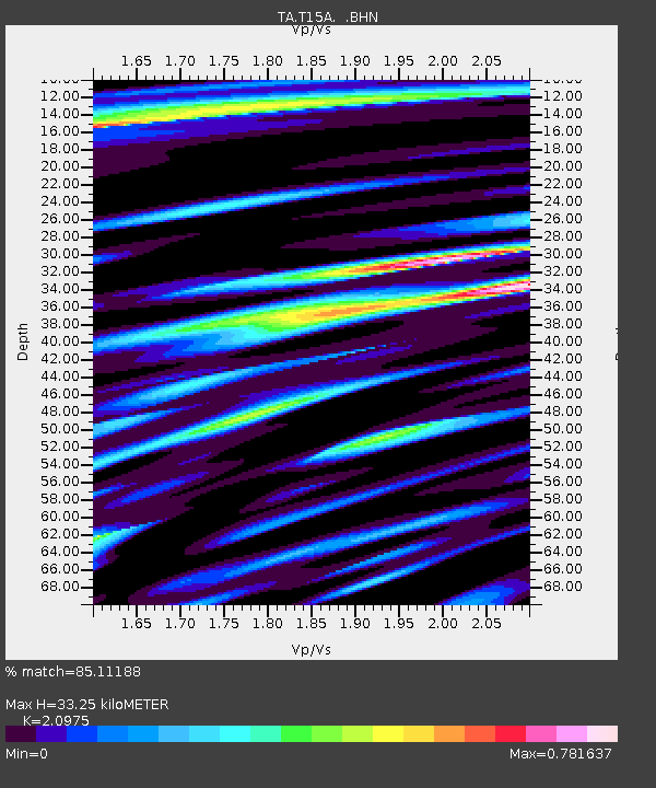
| Estimated Moho Depth: |
33.25 km |
| Estimated Crust Vp/Vs: |
2.10 |
| Assumed Crust Vp: |
6.194 km/s |
| Estimated Crust Vs: |
2.953 km/s |
| Estimated Crust Poisson's Ratio: |
0.35 |
|
| Radial Match: |
85.11188 % |
| Radial Bump: |
400 |
| Transverse Match: |
68.836266 % |
| Transverse Bump: |
400 |
| SOD ConfigId: |
2564 |
| Insert Time: |
2010-03-06 21:42:06.156 +0000 |
| GWidth: |
2.5 |
| Max Bumps: |
400 |
| Tol: |
0.001 |
|

Signal To Noise
| Channel | StoN | STA | LTA |
| TA:T15A: :BHN:20071221T07:32:41.87501Z | 1.4686508 | 3.1870488E-7 | 2.1700521E-7 |
| TA:T15A: :BHE:20071221T07:32:41.87501Z | 2.6487849 | 3.050151E-7 | 1.15152844E-7 |
| TA:T15A: :BHZ:20071221T07:32:41.87501Z | 3.6148608 | 9.806121E-7 | 2.7127246E-7 |
| Arrivals |
| Ps | 6.2 SECOND |
| PpPs | 16 SECOND |
| PsPs/PpSs | 22 SECOND |


