You are here: Home > Network List > TA - USArray Transportable Network (new EarthScope stations) Stations List
> Station I23K Minto, Yukon-Koyukuk, AK, USA > Earthquake Result Viewer
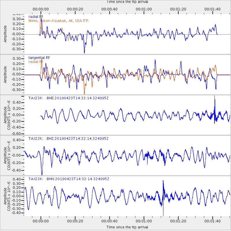
I23K Minto, Yukon-Koyukuk, AK, USA - Earthquake Result Viewer
*The percent match for this event was below the threshold and hence no stack was calculated.
| Earthquake location: |
South Of Fiji Islands |
| Earthquake latitude/longitude: |
-24.7/-178.8 |
| Earthquake time(UTC): |
2019/04/23 (113) 14:20:17 GMT |
| Earthquake Depth: |
386 km |
| Earthquake Magnitude: |
6.0 Mww |
| Earthquake Catalog/Contributor: |
NEIC PDE/us |
|
| Network: |
TA USArray Transportable Network (new EarthScope stations) |
| Station: |
I23K Minto, Yukon-Koyukuk, AK, USA |
| Lat/Lon: |
65.15 N/149.36 W |
| Elevation: |
149 m |
|
| Distance: |
92.4 deg |
| Az: |
11.985 deg |
| Baz: |
206.547 deg |
| Ray Param: |
$rayparam |
*The percent match for this event was below the threshold and hence was not used in the summary stack. |
|
| Radial Match: |
34.347176 % |
| Radial Bump: |
389 |
| Transverse Match: |
61.86401 % |
| Transverse Bump: |
328 |
| SOD ConfigId: |
18252611 |
| Insert Time: |
2019-05-07 14:25:44.893 +0000 |
| GWidth: |
2.5 |
| Max Bumps: |
400 |
| Tol: |
0.001 |
|
Signal To Noise
| Channel | StoN | STA | LTA |
| TA:I23K: :BHZ:20190423T14:32:14.324995Z | 2.72449 | 2.0369023E-7 | 7.47627E-8 |
| TA:I23K: :BHN:20190423T14:32:14.324995Z | 0.6391107 | 8.9957034E-8 | 1.4075346E-7 |
| TA:I23K: :BHE:20190423T14:32:14.324995Z | 0.38659662 | 4.7359503E-8 | 1.2250366E-7 |
| Arrivals |
| Ps | |
| PpPs | |
| PsPs/PpSs | |


