You are here: Home > Network List > TA - USArray Transportable Network (new EarthScope stations) Stations List
> Station M16K Timber Creek, AK, USA > Earthquake Result Viewer
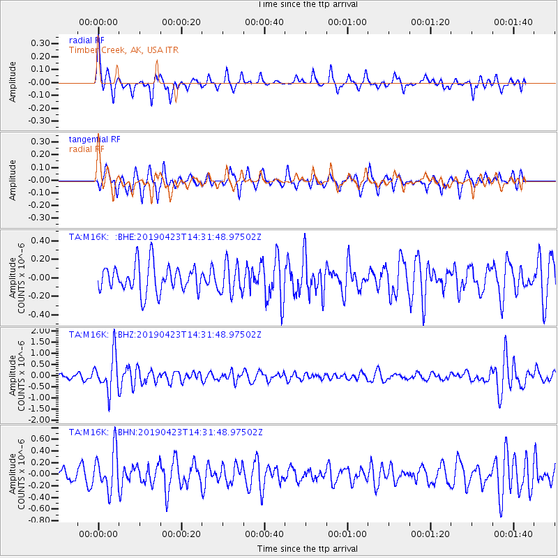
M16K Timber Creek, AK, USA - Earthquake Result Viewer
*The percent match for this event was below the threshold and hence no stack was calculated.
| Earthquake location: |
South Of Fiji Islands |
| Earthquake latitude/longitude: |
-24.7/-178.8 |
| Earthquake time(UTC): |
2019/04/23 (113) 14:20:17 GMT |
| Earthquake Depth: |
386 km |
| Earthquake Magnitude: |
6.0 Mww |
| Earthquake Catalog/Contributor: |
NEIC PDE/us |
|
| Network: |
TA USArray Transportable Network (new EarthScope stations) |
| Station: |
M16K Timber Creek, AK, USA |
| Lat/Lon: |
61.02 N/158.96 W |
| Elevation: |
394 m |
|
| Distance: |
86.9 deg |
| Az: |
9.51 deg |
| Baz: |
197.975 deg |
| Ray Param: |
$rayparam |
*The percent match for this event was below the threshold and hence was not used in the summary stack. |
|
| Radial Match: |
65.76989 % |
| Radial Bump: |
356 |
| Transverse Match: |
65.84169 % |
| Transverse Bump: |
341 |
| SOD ConfigId: |
18252611 |
| Insert Time: |
2019-05-07 14:25:58.923 +0000 |
| GWidth: |
2.5 |
| Max Bumps: |
400 |
| Tol: |
0.001 |
|
Signal To Noise
| Channel | StoN | STA | LTA |
| TA:M16K: :BHZ:20190423T14:31:48.97502Z | 6.3373976 | 8.3037423E-7 | 1.3102763E-7 |
| TA:M16K: :BHN:20190423T14:31:48.97502Z | 2.520484 | 3.5388922E-7 | 1.4040528E-7 |
| TA:M16K: :BHE:20190423T14:31:48.97502Z | 1.111546 | 1.6367993E-7 | 1.4725428E-7 |
| Arrivals |
| Ps | |
| PpPs | |
| PsPs/PpSs | |


