You are here: Home > Network List > TA - USArray Transportable Network (new EarthScope stations) Stations List
> Station P17K Kvichak River, AK, USA > Earthquake Result Viewer
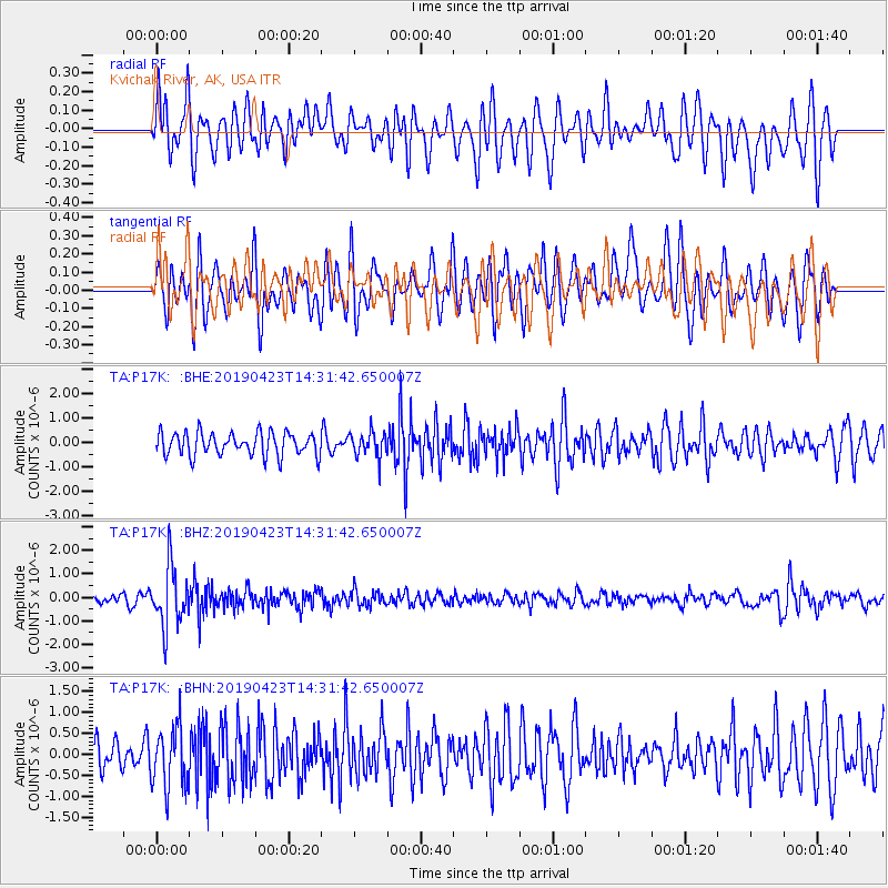
P17K Kvichak River, AK, USA - Earthquake Result Viewer
*The percent match for this event was below the threshold and hence no stack was calculated.
| Earthquake location: |
South Of Fiji Islands |
| Earthquake latitude/longitude: |
-24.7/-178.8 |
| Earthquake time(UTC): |
2019/04/23 (113) 14:20:17 GMT |
| Earthquake Depth: |
386 km |
| Earthquake Magnitude: |
6.0 Mww |
| Earthquake Catalog/Contributor: |
NEIC PDE/us |
|
| Network: |
TA USArray Transportable Network (new EarthScope stations) |
| Station: |
P17K Kvichak River, AK, USA |
| Lat/Lon: |
59.20 N/156.44 W |
| Elevation: |
91 m |
|
| Distance: |
85.6 deg |
| Az: |
11.307 deg |
| Baz: |
200.274 deg |
| Ray Param: |
$rayparam |
*The percent match for this event was below the threshold and hence was not used in the summary stack. |
|
| Radial Match: |
62.35867 % |
| Radial Bump: |
400 |
| Transverse Match: |
63.68161 % |
| Transverse Bump: |
400 |
| SOD ConfigId: |
18252611 |
| Insert Time: |
2019-05-07 14:26:12.873 +0000 |
| GWidth: |
2.5 |
| Max Bumps: |
400 |
| Tol: |
0.001 |
|
Signal To Noise
| Channel | StoN | STA | LTA |
| TA:P17K: :BHZ:20190423T14:31:42.650007Z | 6.7168603 | 1.2557452E-6 | 1.869542E-7 |
| TA:P17K: :BHN:20190423T14:31:42.650007Z | 1.674944 | 7.341948E-7 | 4.3833992E-7 |
| TA:P17K: :BHE:20190423T14:31:42.650007Z | 1.1099902 | 5.169293E-7 | 4.6570617E-7 |
| Arrivals |
| Ps | |
| PpPs | |
| PsPs/PpSs | |


