You are here: Home > Network List > TA - USArray Transportable Network (new EarthScope stations) Stations List
> Station T15A Red Dirt Ranch, Kanab, UT, USA > Earthquake Result Viewer
T15A Red Dirt Ranch, Kanab, UT, USA - Earthquake Result Viewer
| Earthquake location: |
Tonga Islands |
| Earthquake latitude/longitude: |
-17.5/-174.3 |
| Earthquake time(UTC): |
2007/08/26 (238) 12:37:31 GMT |
| Earthquake Depth: |
127 km |
| Earthquake Magnitude: |
5.9 MB, 6.1 MW |
| Earthquake Catalog/Contributor: |
WHDF/NEIC |
|
| Network: |
TA USArray Transportable Network (new EarthScope stations) |
| Station: |
T15A Red Dirt Ranch, Kanab, UT, USA |
| Lat/Lon: |
37.02 N/112.38 W |
| Elevation: |
1561 m |
|
| Distance: |
79.6 deg |
| Az: |
45.904 deg |
| Baz: |
238.924 deg |
| Ray Param: |
0.04855071 |
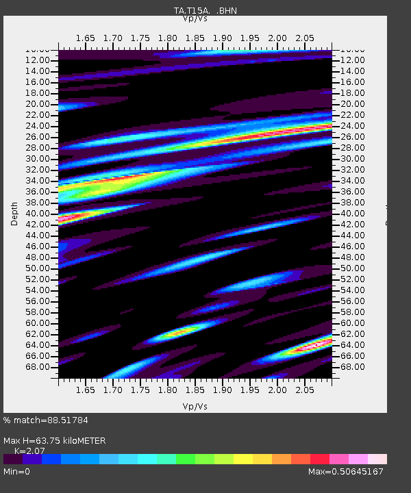
| Estimated Moho Depth: |
63.75 km |
| Estimated Crust Vp/Vs: |
2.07 |
| Assumed Crust Vp: |
6.194 km/s |
| Estimated Crust Vs: |
2.992 km/s |
| Estimated Crust Poisson's Ratio: |
0.35 |
|
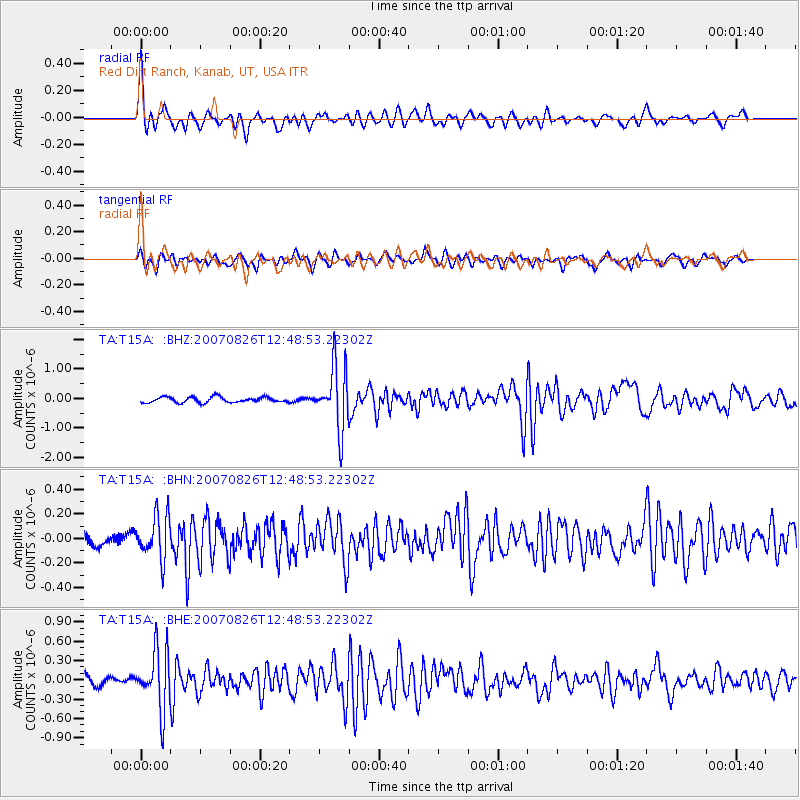
| Radial Match: |
88.51784 % |
| Radial Bump: |
400 |
| Transverse Match: |
82.86945 % |
| Transverse Bump: |
400 |
| SOD ConfigId: |
2564 |
| Insert Time: |
2010-03-06 21:42:25.341 +0000 |
| GWidth: |
2.5 |
| Max Bumps: |
400 |
| Tol: |
0.001 |
|
Signal To Noise
| Channel | StoN | STA | LTA |
| TA:T15A: :BHN:20070826T12:48:53.22302Z | 2.7188501 | 1.762805E-7 | 6.4836414E-8 |
| TA:T15A: :BHE:20070826T12:48:53.22302Z | 8.022853 | 4.5987116E-7 | 5.732015E-8 |
| TA:T15A: :BHZ:20070826T12:48:53.22302Z | 11.471774 | 1.0514867E-6 | 9.165859E-8 |
| Arrivals |
| Ps | 11 SECOND |
| PpPs | 31 SECOND |
| PsPs/PpSs | 42 SECOND |


