You are here: Home > Network List > TA - USArray Transportable Network (new EarthScope stations) Stations List
> Station R33M Jennings River, BC, CAN > Earthquake Result Viewer
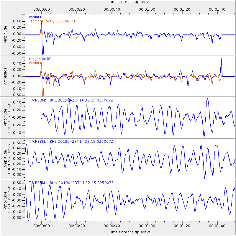
R33M Jennings River, BC, CAN - Earthquake Result Viewer
*The percent match for this event was below the threshold and hence no stack was calculated.
| Earthquake location: |
South Of Fiji Islands |
| Earthquake latitude/longitude: |
-24.7/-178.8 |
| Earthquake time(UTC): |
2019/04/23 (113) 14:20:17 GMT |
| Earthquake Depth: |
386 km |
| Earthquake Magnitude: |
6.0 Mww |
| Earthquake Catalog/Contributor: |
NEIC PDE/us |
|
| Network: |
TA USArray Transportable Network (new EarthScope stations) |
| Station: |
R33M Jennings River, BC, CAN |
| Lat/Lon: |
59.39 N/130.97 W |
| Elevation: |
1437 m |
|
| Distance: |
92.6 deg |
| Az: |
22.296 deg |
| Baz: |
222.409 deg |
| Ray Param: |
$rayparam |
*The percent match for this event was below the threshold and hence was not used in the summary stack. |
|
| Radial Match: |
72.79731 % |
| Radial Bump: |
400 |
| Transverse Match: |
48.02045 % |
| Transverse Bump: |
400 |
| SOD ConfigId: |
18252611 |
| Insert Time: |
2019-05-07 14:26:18.695 +0000 |
| GWidth: |
2.5 |
| Max Bumps: |
400 |
| Tol: |
0.001 |
|
Signal To Noise
| Channel | StoN | STA | LTA |
| TA:R33M: :BHZ:20190423T14:32:15.025007Z | 0.84354806 | 2.0957793E-7 | 2.4844812E-7 |
| TA:R33M: :BHN:20190423T14:32:15.025007Z | 1.7022809 | 4.6356587E-7 | 2.7232045E-7 |
| TA:R33M: :BHE:20190423T14:32:15.025007Z | 0.8702086 | 1.9714341E-7 | 2.2654729E-7 |
| Arrivals |
| Ps | |
| PpPs | |
| PsPs/PpSs | |


