You are here: Home > Network List > TA - USArray Transportable Network (new EarthScope stations) Stations List
> Station T15A Red Dirt Ranch, Kanab, UT, USA > Earthquake Result Viewer
T15A Red Dirt Ranch, Kanab, UT, USA - Earthquake Result Viewer

| Earthquake location: |
Near Coast Of Peru |
| Earthquake latitude/longitude: |
-15.7/-74.9 |
| Earthquake time(UTC): |
2007/06/28 (179) 08:44:48 GMT |
| Earthquake Depth: |
27 km |
| Earthquake Magnitude: |
5.5 MB, 5.3 MS, 5.8 MW, 5.8 MW |
| Earthquake Catalog/Contributor: |
WHDF/NEIC |
|
| Network: |
TA USArray Transportable Network (new EarthScope stations) |
| Station: |
T15A Red Dirt Ranch, Kanab, UT, USA |
| Lat/Lon: |
37.02 N/112.38 W |
| Elevation: |
1561 m |
|
| Distance: |
63.2 deg |
| Az: |
326.927 deg |
| Baz: |
138.949 deg |
| Ray Param: |
0.05968113 |
| Estimated Moho Depth: |
16.75 km |
| Estimated Crust Vp/Vs: |
1.60 |
| Assumed Crust Vp: |
6.194 km/s |
| Estimated Crust Vs: |
3.871 km/s |
| Estimated Crust Poisson's Ratio: |
0.18 |
|
| Radial Match: |
80.00865 % |
| Radial Bump: |
400 |
| Transverse Match: |
55.578465 % |
| Transverse Bump: |
400 |
| SOD ConfigId: |
2564 |
| Insert Time: |
2010-03-06 21:42:55.273 +0000 |
| GWidth: |
2.5 |
| Max Bumps: |
400 |
| Tol: |
0.001 |
|
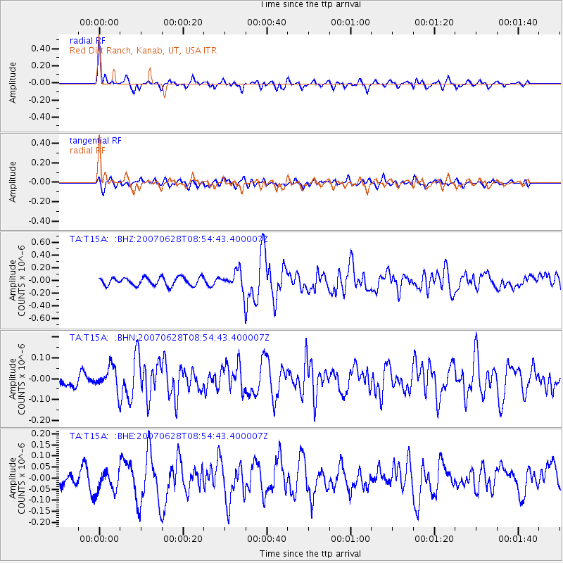
Signal To Noise
| Channel | StoN | STA | LTA |
| TA:T15A: :BHN:20070628T08:54:43.400007Z | 1.614126 | 5.888608E-8 | 3.6481712E-8 |
| TA:T15A: :BHE:20070628T08:54:43.400007Z | 1.0149248 | 4.652119E-8 | 4.5837083E-8 |
| TA:T15A: :BHZ:20070628T08:54:43.400007Z | 2.6324747 | 1.6864477E-7 | 6.406321E-8 |
| Arrivals |
| Ps | 1.7 SECOND |
| PpPs | 6.7 SECOND |
| PsPs/PpSs | 8.4 SECOND |


