You are here: Home > Network List > TA - USArray Transportable Network (new EarthScope stations) Stations List
> Station T15A Red Dirt Ranch, Kanab, UT, USA > Earthquake Result Viewer
T15A Red Dirt Ranch, Kanab, UT, USA - Earthquake Result Viewer
| Earthquake location: |
Kamchatka Peninsula, Russia |
| Earthquake latitude/longitude: |
52.1/157.3 |
| Earthquake time(UTC): |
2007/05/30 (150) 20:22:12 GMT |
| Earthquake Depth: |
116 km |
| Earthquake Magnitude: |
6.4 MB, 6.4 MW, 6.4 MW |
| Earthquake Catalog/Contributor: |
WHDF/NEIC |
|
| Network: |
TA USArray Transportable Network (new EarthScope stations) |
| Station: |
T15A Red Dirt Ranch, Kanab, UT, USA |
| Lat/Lon: |
37.02 N/112.38 W |
| Elevation: |
1561 m |
|
| Distance: |
62.0 deg |
| Az: |
65.009 deg |
| Baz: |
315.736 deg |
| Ray Param: |
0.060173504 |
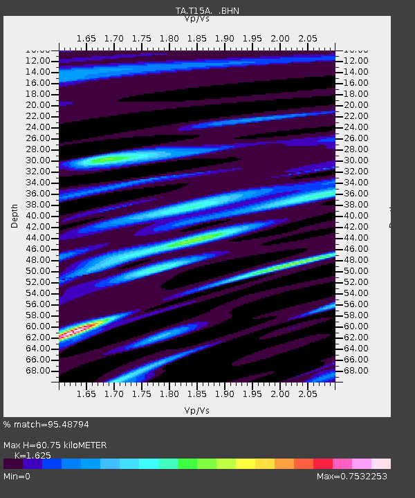
| Estimated Moho Depth: |
60.75 km |
| Estimated Crust Vp/Vs: |
1.62 |
| Assumed Crust Vp: |
6.194 km/s |
| Estimated Crust Vs: |
3.812 km/s |
| Estimated Crust Poisson's Ratio: |
0.20 |
|
| Radial Match: |
95.48794 % |
| Radial Bump: |
362 |
| Transverse Match: |
87.591835 % |
| Transverse Bump: |
400 |
| SOD ConfigId: |
2564 |
| Insert Time: |
2010-03-06 21:42:58.421 +0000 |
| GWidth: |
2.5 |
| Max Bumps: |
400 |
| Tol: |
0.001 |
|

Signal To Noise
| Channel | StoN | STA | LTA |
| TA:T15A: :BHN:20070530T20:31:49.899014Z | 25.39997 | 1.0279147E-6 | 4.046913E-8 |
| TA:T15A: :BHE:20070530T20:31:49.899014Z | 32.189034 | 1.2821671E-6 | 3.9832422E-8 |
| TA:T15A: :BHZ:20070530T20:31:49.899014Z | 58.060837 | 4.5399415E-6 | 7.819284E-8 |
| Arrivals |
| Ps | 6.4 SECOND |
| PpPs | 25 SECOND |
| PsPs/PpSs | 31 SECOND |


