You are here: Home > Network List > TS - TERRAscope (Southern California Seismic Network) Stations List
> Station DGR Domenigoni Valley Reservior, California, USA > Earthquake Result Viewer
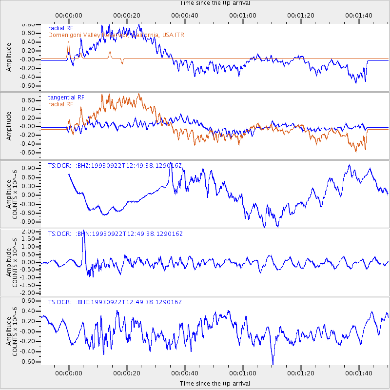
DGR Domenigoni Valley Reservior, California, USA - Earthquake Result Viewer
*The percent match for this event was below the threshold and hence no stack was calculated.
| Earthquake location: |
Solomon Islands |
| Earthquake latitude/longitude: |
-6.5/154.9 |
| Earthquake time(UTC): |
1993/09/22 (265) 12:37:06 GMT |
| Earthquake Depth: |
49 km |
| Earthquake Magnitude: |
6.1 MB, 6.0 MS, 6.0 UNKNOWN, 6.2 MW |
| Earthquake Catalog/Contributor: |
WHDF/NEIC |
|
| Network: |
TS TERRAscope (Southern California Seismic Network) |
| Station: |
DGR Domenigoni Valley Reservior, California, USA |
| Lat/Lon: |
33.65 N/117.01 W |
| Elevation: |
700 m |
|
| Distance: |
91.9 deg |
| Az: |
56.527 deg |
| Baz: |
263.588 deg |
| Ray Param: |
$rayparam |
*The percent match for this event was below the threshold and hence was not used in the summary stack. |
|
| Radial Match: |
52.435497 % |
| Radial Bump: |
400 |
| Transverse Match: |
54.314735 % |
| Transverse Bump: |
400 |
| SOD ConfigId: |
4480 |
| Insert Time: |
2010-02-26 14:11:05.597 +0000 |
| GWidth: |
2.5 |
| Max Bumps: |
400 |
| Tol: |
0.001 |
|
Signal To Noise
| Channel | StoN | STA | LTA |
| TS:DGR: :BHN:19930922T12:49:38.129016Z | 4.2055364 | 3.5343083E-7 | 8.403942E-8 |
| TS:DGR: :BHE:19930922T12:49:38.129016Z | 0.8723018 | 1.552168E-7 | 1.7793931E-7 |
| TS:DGR: :BHZ:19930922T12:49:38.129016Z | 1.7466856 | 5.522857E-7 | 3.161907E-7 |
| Arrivals |
| Ps | |
| PpPs | |
| PsPs/PpSs | |


