You are here: Home > Network List > TA - USArray Transportable Network (new EarthScope stations) Stations List
> Station T15A Red Dirt Ranch, Kanab, UT, USA > Earthquake Result Viewer
T15A Red Dirt Ranch, Kanab, UT, USA - Earthquake Result Viewer
| Earthquake location: |
South Of Panama |
| Earthquake latitude/longitude: |
5.0/-82.7 |
| Earthquake time(UTC): |
2008/06/17 (169) 17:42:09 GMT |
| Earthquake Depth: |
10 km |
| Earthquake Magnitude: |
5.6 MB, 5.3 MS, 5.9 MW, 5.9 MW |
| Earthquake Catalog/Contributor: |
WHDF/NEIC |
|
| Network: |
TA USArray Transportable Network (new EarthScope stations) |
| Station: |
T15A Red Dirt Ranch, Kanab, UT, USA |
| Lat/Lon: |
37.02 N/112.38 W |
| Elevation: |
1561 m |
|
| Distance: |
41.9 deg |
| Az: |
323.528 deg |
| Baz: |
132.278 deg |
| Ray Param: |
0.07350293 |
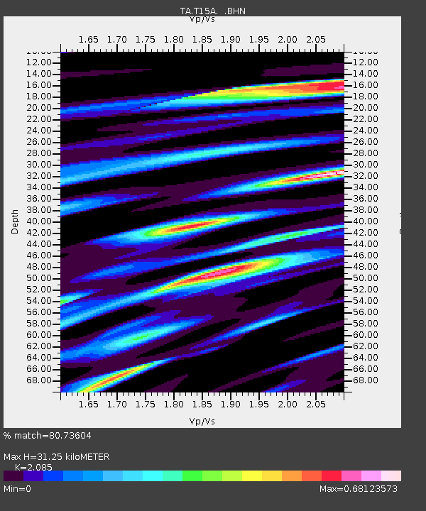
| Estimated Moho Depth: |
31.25 km |
| Estimated Crust Vp/Vs: |
2.09 |
| Assumed Crust Vp: |
6.194 km/s |
| Estimated Crust Vs: |
2.971 km/s |
| Estimated Crust Poisson's Ratio: |
0.35 |
|
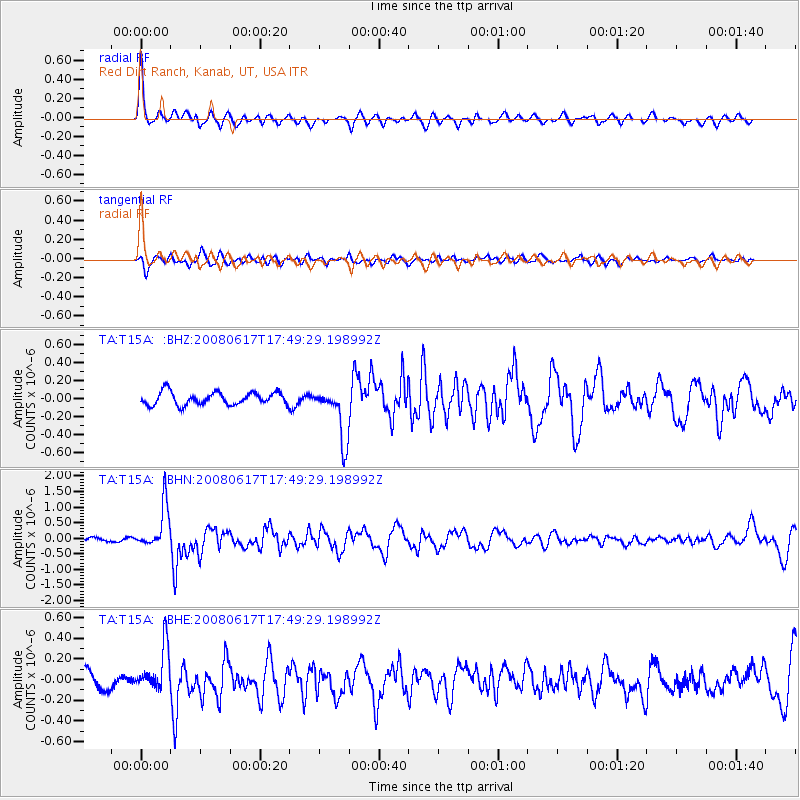
| Radial Match: |
80.73604 % |
| Radial Bump: |
400 |
| Transverse Match: |
67.0018 % |
| Transverse Bump: |
400 |
| SOD ConfigId: |
2504 |
| Insert Time: |
2010-03-06 21:43:12.714 +0000 |
| GWidth: |
2.5 |
| Max Bumps: |
400 |
| Tol: |
0.001 |
|
Signal To Noise
| Channel | StoN | STA | LTA |
| TA:T15A: :BHN:20080617T17:49:29.198992Z | 9.454759 | 6.9670256E-7 | 7.3688035E-8 |
| TA:T15A: :BHE:20080617T17:49:29.198992Z | 2.362874 | 2.1634187E-7 | 9.155879E-8 |
| TA:T15A: :BHZ:20080617T17:49:29.198992Z | 4.204817 | 2.9895787E-7 | 7.109891E-8 |
| Arrivals |
| Ps | 5.8 SECOND |
| PpPs | 15 SECOND |
| PsPs/PpSs | 21 SECOND |


