You are here: Home > Network List > JP - Japan Meteorological Agency Seismic Network Stations List
> Station JSD Sado > Earthquake Result Viewer
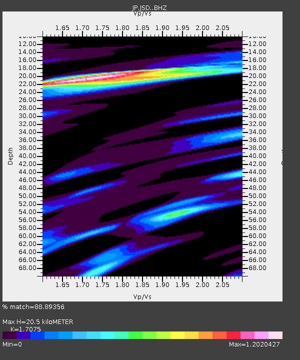
JSD Sado - Earthquake Result Viewer
| Earthquake location: |
Eastern Xizang-India Border Reg. |
| Earthquake latitude/longitude: |
28.4/94.6 |
| Earthquake time(UTC): |
2019/04/23 (113) 20:15:50 GMT |
| Earthquake Depth: |
14 km |
| Earthquake Magnitude: |
5.9 Mww |
| Earthquake Catalog/Contributor: |
NEIC PDE/us |
|
| Network: |
JP Japan Meteorological Agency Seismic Network |
| Station: |
JSD Sado |
| Lat/Lon: |
38.04 N/138.26 E |
| Elevation: |
146 m |
|
| Distance: |
37.5 deg |
| Az: |
63.639 deg |
| Baz: |
268.371 deg |
| Ray Param: |
0.07610835 |
| Estimated Moho Depth: |
20.5 km |
| Estimated Crust Vp/Vs: |
1.71 |
| Assumed Crust Vp: |
6.183 km/s |
| Estimated Crust Vs: |
3.621 km/s |
| Estimated Crust Poisson's Ratio: |
0.24 |
|
| Radial Match: |
88.89356 % |
| Radial Bump: |
250 |
| Transverse Match: |
75.1928 % |
| Transverse Bump: |
400 |
| SOD ConfigId: |
18252611 |
| Insert Time: |
2019-05-07 20:18:56.086 +0000 |
| GWidth: |
2.5 |
| Max Bumps: |
400 |
| Tol: |
0.001 |
|

Signal To Noise
| Channel | StoN | STA | LTA |
| JP:JSD: :BHZ:20190423T20:22:33.000014Z | 8.607127 | 4.3230088E-7 | 5.022592E-8 |
| JP:JSD: :BHN:20190423T20:22:33.000014Z | 0.77665454 | 5.131888E-8 | 6.607684E-8 |
| JP:JSD: :BHE:20190423T20:22:33.000014Z | 7.0360975 | 2.2963401E-7 | 3.2636557E-8 |
| Arrivals |
| Ps | 2.5 SECOND |
| PpPs | 8.4 SECOND |
| PsPs/PpSs | 11 SECOND |


