You are here: Home > Network List > TS - TERRAscope (Southern California Seismic Network) Stations List
> Station DGR Domenigoni Valley Reservior, California, USA > Earthquake Result Viewer
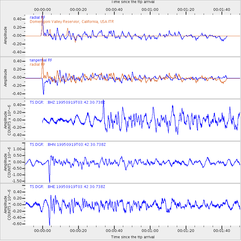
DGR Domenigoni Valley Reservior, California, USA - Earthquake Result Viewer
*The percent match for this event was below the threshold and hence no stack was calculated.
| Earthquake location: |
Chile-Bolivia Border Region |
| Earthquake latitude/longitude: |
-21.2/-68.7 |
| Earthquake time(UTC): |
1995/09/19 (262) 03:31:53 GMT |
| Earthquake Depth: |
110 km |
| Earthquake Magnitude: |
5.7 MB, 5.7 UNKNOWN, 5.6 MW |
| Earthquake Catalog/Contributor: |
WHDF/NEIC |
|
| Network: |
TS TERRAscope (Southern California Seismic Network) |
| Station: |
DGR Domenigoni Valley Reservior, California, USA |
| Lat/Lon: |
33.65 N/117.01 W |
| Elevation: |
700 m |
|
| Distance: |
71.4 deg |
| Az: |
318.934 deg |
| Baz: |
132.713 deg |
| Ray Param: |
$rayparam |
*The percent match for this event was below the threshold and hence was not used in the summary stack. |
|
| Radial Match: |
60.911625 % |
| Radial Bump: |
400 |
| Transverse Match: |
56.669395 % |
| Transverse Bump: |
400 |
| SOD ConfigId: |
4480 |
| Insert Time: |
2010-02-26 14:11:07.978 +0000 |
| GWidth: |
2.5 |
| Max Bumps: |
400 |
| Tol: |
0.001 |
|
Signal To Noise
| Channel | StoN | STA | LTA |
| TS:DGR: :BHN:19950919T03:42:30.738Z | 4.5125256 | 4.4956252E-7 | 9.9625474E-8 |
| TS:DGR: :BHE:19950919T03:42:30.738Z | 5.243352 | 2.1736702E-7 | 4.1455735E-8 |
| TS:DGR: :BHZ:19950919T03:42:30.738Z | 2.855635 | 1.5973261E-7 | 5.5935935E-8 |
| Arrivals |
| Ps | |
| PpPs | |
| PsPs/PpSs | |


