You are here: Home > Network List > TA - USArray Transportable Network (new EarthScope stations) Stations List
> Station A21K Barrow, AK, USA > Earthquake Result Viewer
A21K Barrow, AK, USA - Earthquake Result Viewer
| Earthquake location: |
Eastern Xizang-India Border Reg. |
| Earthquake latitude/longitude: |
28.4/94.6 |
| Earthquake time(UTC): |
2019/04/23 (113) 20:15:50 GMT |
| Earthquake Depth: |
14 km |
| Earthquake Magnitude: |
5.9 Mww |
| Earthquake Catalog/Contributor: |
NEIC PDE/us |
|
| Network: |
TA USArray Transportable Network (new EarthScope stations) |
| Station: |
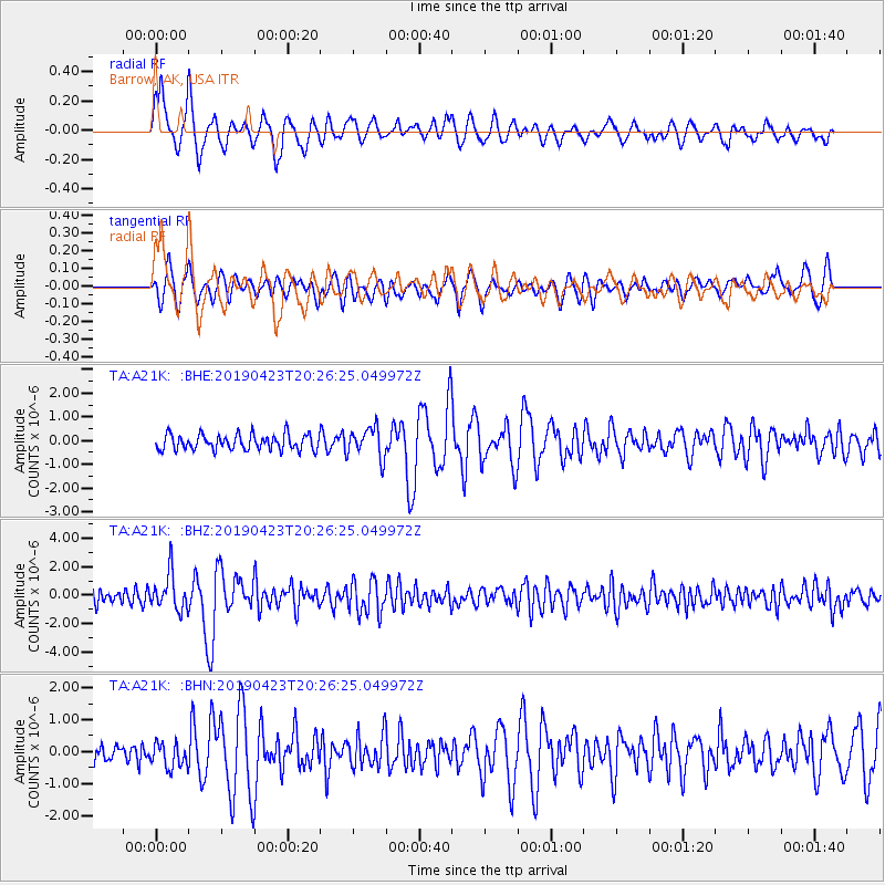
A21K Barrow, AK, USA |
| Lat/Lon: |
71.32 N/156.62 W |
| Elevation: |
577 m |
|
| Distance: |
69.1 deg |
| Az: |
19.057 deg |
| Baz: |
296.787 deg |
| Ray Param: |
0.055862945 |
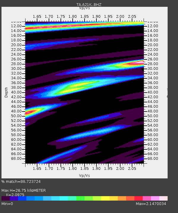
| Estimated Moho Depth: |
26.75 km |
| Estimated Crust Vp/Vs: |
2.10 |
| Assumed Crust Vp: |
6.048 km/s |
| Estimated Crust Vs: |
2.883 km/s |
| Estimated Crust Poisson's Ratio: |
0.35 |
|
| Radial Match: |
88.723724 % |
| Radial Bump: |
400 |
| Transverse Match: |
79.08252 % |
| Transverse Bump: |
396 |
| SOD ConfigId: |
18252611 |
| Insert Time: |
2019-05-07 20:19:49.752 +0000 |
| GWidth: |
2.5 |
| Max Bumps: |
400 |
| Tol: |
0.001 |
|
Signal To Noise
| Channel | StoN | STA | LTA |
| TA:A21K: :BHZ:20190423T20:26:25.049972Z | 2.5718896 | 1.3015498E-6 | 5.060675E-7 |
| TA:A21K: :BHN:20190423T20:26:25.049972Z | 1.2188411 | 3.8891878E-7 | 3.1908903E-7 |
| TA:A21K: :BHE:20190423T20:26:25.049972Z | 1.962162 | 6.384165E-7 | 3.2536383E-7 |
| Arrivals |
| Ps | 5.0 SECOND |
| PpPs | 13 SECOND |
| PsPs/PpSs | 18 SECOND |


