You are here: Home > Network List > TA - USArray Transportable Network (new EarthScope stations) Stations List
> Station B18K Kokolik River, AK, USA > Earthquake Result Viewer
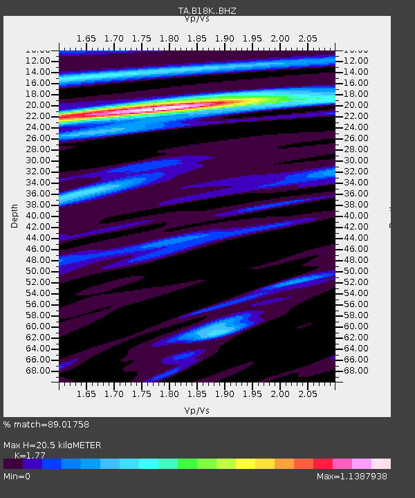
B18K Kokolik River, AK, USA - Earthquake Result Viewer
| Earthquake location: |
Eastern Xizang-India Border Reg. |
| Earthquake latitude/longitude: |
28.4/94.6 |
| Earthquake time(UTC): |
2019/04/23 (113) 20:15:50 GMT |
| Earthquake Depth: |
14 km |
| Earthquake Magnitude: |
5.9 Mww |
| Earthquake Catalog/Contributor: |
NEIC PDE/us |
|
| Network: |
TA USArray Transportable Network (new EarthScope stations) |
| Station: |
B18K Kokolik River, AK, USA |
| Lat/Lon: |
69.36 N/161.80 W |
| Elevation: |
222 m |
|
| Distance: |
68.3 deg |
| Az: |
21.763 deg |
| Baz: |
292.89 deg |
| Ray Param: |
0.056363884 |
| Estimated Moho Depth: |
20.5 km |
| Estimated Crust Vp/Vs: |
1.77 |
| Assumed Crust Vp: |
5.906 km/s |
| Estimated Crust Vs: |
3.337 km/s |
| Estimated Crust Poisson's Ratio: |
0.27 |
|
| Radial Match: |
89.01758 % |
| Radial Bump: |
400 |
| Transverse Match: |
87.63188 % |
| Transverse Bump: |
400 |
| SOD ConfigId: |
18252611 |
| Insert Time: |
2019-05-07 20:19:49.936 +0000 |
| GWidth: |
2.5 |
| Max Bumps: |
400 |
| Tol: |
0.001 |
|

Signal To Noise
| Channel | StoN | STA | LTA |
| TA:B18K: :BHZ:20190423T20:26:20.275008Z | 11.231807 | 1.2561908E-6 | 1.11842276E-7 |
| TA:B18K: :BHN:20190423T20:26:20.275008Z | 1.7789395 | 1.396301E-7 | 7.849064E-8 |
| TA:B18K: :BHE:20190423T20:26:20.275008Z | 4.6915536 | 3.1293249E-7 | 6.670125E-8 |
| Arrivals |
| Ps | 2.8 SECOND |
| PpPs | 9.3 SECOND |
| PsPs/PpSs | 12 SECOND |


