You are here: Home > Network List > TA - USArray Transportable Network (new EarthScope stations) Stations List
> Station E29M Blow River, YT, CAN > Earthquake Result Viewer
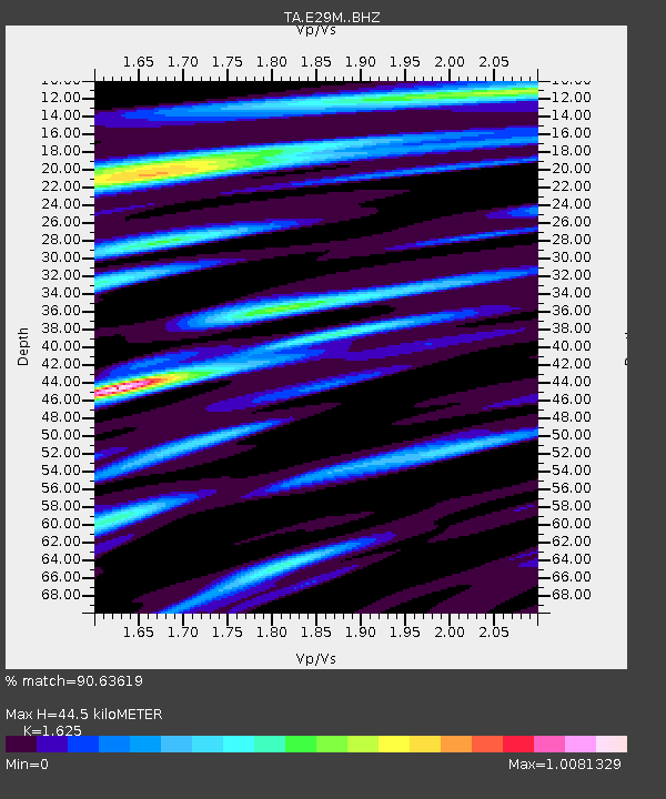
E29M Blow River, YT, CAN - Earthquake Result Viewer
| Earthquake location: |
Eastern Xizang-India Border Reg. |
| Earthquake latitude/longitude: |
28.4/94.6 |
| Earthquake time(UTC): |
2019/04/23 (113) 20:15:50 GMT |
| Earthquake Depth: |
14 km |
| Earthquake Magnitude: |
5.9 Mww |
| Earthquake Catalog/Contributor: |
NEIC PDE/us |
|
| Network: |
TA USArray Transportable Network (new EarthScope stations) |
| Station: |
E29M Blow River, YT, CAN |
| Lat/Lon: |
68.39 N/137.90 W |
| Elevation: |
324 m |
|
| Distance: |
76.1 deg |
| Az: |
17.626 deg |
| Baz: |
313.944 deg |
| Ray Param: |
0.051245857 |
| Estimated Moho Depth: |
44.5 km |
| Estimated Crust Vp/Vs: |
1.62 |
| Assumed Crust Vp: |
5.981 km/s |
| Estimated Crust Vs: |
3.681 km/s |
| Estimated Crust Poisson's Ratio: |
0.20 |
|
| Radial Match: |
90.63619 % |
| Radial Bump: |
400 |
| Transverse Match: |
85.80089 % |
| Transverse Bump: |
400 |
| SOD ConfigId: |
18252611 |
| Insert Time: |
2019-05-07 20:20:08.373 +0000 |
| GWidth: |
2.5 |
| Max Bumps: |
400 |
| Tol: |
0.001 |
|

Signal To Noise
| Channel | StoN | STA | LTA |
| TA:E29M: :BHZ:20190423T20:27:06.324996Z | 17.762678 | 1.0813822E-6 | 6.087945E-8 |
| TA:E29M: :BHN:20190423T20:27:06.324996Z | 2.6856608 | 1.9354295E-7 | 7.20653E-8 |
| TA:E29M: :BHE:20190423T20:27:06.324996Z | 2.4864209 | 2.769778E-7 | 1.1139619E-7 |
| Arrivals |
| Ps | 4.8 SECOND |
| PpPs | 19 SECOND |
| PsPs/PpSs | 24 SECOND |


