You are here: Home > Network List > TA - USArray Transportable Network (new EarthScope stations) Stations List
> Station G19K Purcell Mountains, AK, USA > Earthquake Result Viewer
G19K Purcell Mountains, AK, USA - Earthquake Result Viewer
| Earthquake location: |
Eastern Xizang-India Border Reg. |
| Earthquake latitude/longitude: |
28.4/94.6 |
| Earthquake time(UTC): |
2019/04/23 (113) 20:15:50 GMT |
| Earthquake Depth: |
14 km |
| Earthquake Magnitude: |
5.9 Mww |
| Earthquake Catalog/Contributor: |
NEIC PDE/us |
|
| Network: |
TA USArray Transportable Network (new EarthScope stations) |
| Station: |
G19K Purcell Mountains, AK, USA |
| Lat/Lon: |
66.14 N/157.09 W |
| Elevation: |
391 m |
|
| Distance: |
71.3 deg |
| Az: |
24.05 deg |
| Baz: |
298.04 deg |
| Ray Param: |
0.054382436 |
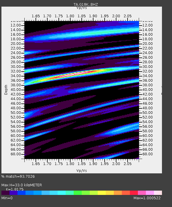
| Estimated Moho Depth: |
33.0 km |
| Estimated Crust Vp/Vs: |
1.82 |
| Assumed Crust Vp: |
6.577 km/s |
| Estimated Crust Vs: |
3.619 km/s |
| Estimated Crust Poisson's Ratio: |
0.28 |
|
| Radial Match: |
93.7026 % |
| Radial Bump: |
400 |
| Transverse Match: |
92.572334 % |
| Transverse Bump: |
400 |
| SOD ConfigId: |
18252611 |
| Insert Time: |
2019-05-07 20:20:19.877 +0000 |
| GWidth: |
2.5 |
| Max Bumps: |
400 |
| Tol: |
0.001 |
|

Signal To Noise
| Channel | StoN | STA | LTA |
| TA:G19K: :BHZ:20190423T20:26:38.775008Z | 24.16558 | 1.0223495E-6 | 4.2306013E-8 |
| TA:G19K: :BHN:20190423T20:26:38.775008Z | 3.6119032 | 1.3469885E-7 | 3.7293038E-8 |
| TA:G19K: :BHE:20190423T20:26:38.775008Z | 11.862916 | 4.2965064E-7 | 3.6217966E-8 |
| Arrivals |
| Ps | 4.3 SECOND |
| PpPs | 14 SECOND |
| PsPs/PpSs | 18 SECOND |


