You are here: Home > Network List > TA - USArray Transportable Network (new EarthScope stations) Stations List
> Station G23K Bananza Creek, AK, USA > Earthquake Result Viewer
G23K Bananza Creek, AK, USA - Earthquake Result Viewer
| Earthquake location: |
Eastern Xizang-India Border Reg. |
| Earthquake latitude/longitude: |
28.4/94.6 |
| Earthquake time(UTC): |
2019/04/23 (113) 20:15:50 GMT |
| Earthquake Depth: |
14 km |
| Earthquake Magnitude: |
5.9 Mww |
| Earthquake Catalog/Contributor: |
NEIC PDE/us |
|
| Network: |
TA USArray Transportable Network (new EarthScope stations) |
| Station: |
G23K Bananza Creek, AK, USA |
| Lat/Lon: |
66.71 N/150.02 W |
| Elevation: |
746 m |
|
| Distance: |
73.5 deg |
| Az: |
22.006 deg |
| Baz: |
303.891 deg |
| Ray Param: |
0.052963622 |
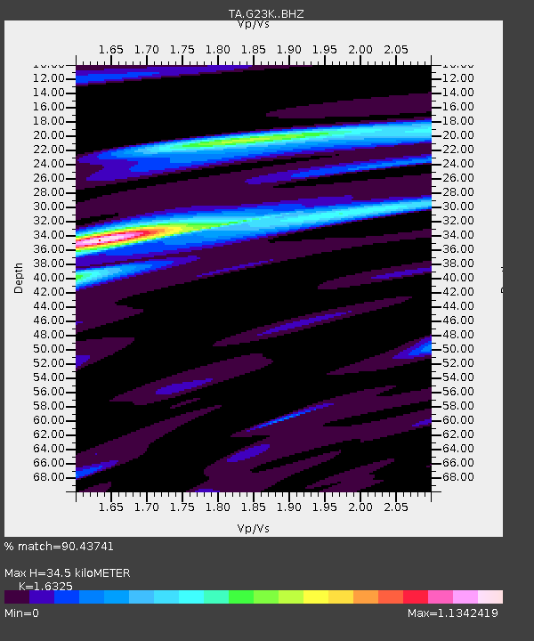
| Estimated Moho Depth: |
34.5 km |
| Estimated Crust Vp/Vs: |
1.63 |
| Assumed Crust Vp: |
6.577 km/s |
| Estimated Crust Vs: |
4.029 km/s |
| Estimated Crust Poisson's Ratio: |
0.20 |
|
| Radial Match: |
90.43741 % |
| Radial Bump: |
332 |
| Transverse Match: |
85.74262 % |
| Transverse Bump: |
400 |
| SOD ConfigId: |
18252611 |
| Insert Time: |
2019-05-07 20:20:20.350 +0000 |
| GWidth: |
2.5 |
| Max Bumps: |
400 |
| Tol: |
0.001 |
|
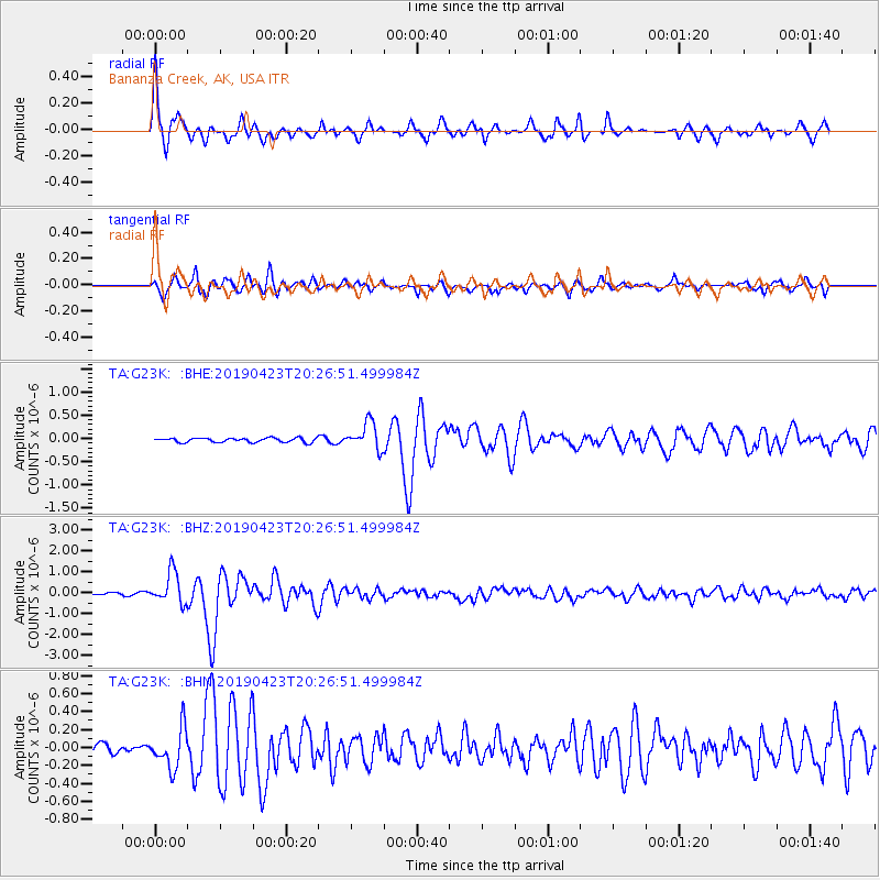
Signal To Noise
| Channel | StoN | STA | LTA |
| TA:G23K: :BHZ:20190423T20:26:51.499984Z | 13.670856 | 7.5124126E-7 | 5.4952025E-8 |
| TA:G23K: :BHN:20190423T20:26:51.499984Z | 3.8895748 | 2.1886537E-7 | 5.626974E-8 |
| TA:G23K: :BHE:20190423T20:26:51.499984Z | 6.2128954 | 2.8710147E-7 | 4.6210573E-8 |
| Arrivals |
| Ps | 3.4 SECOND |
| PpPs | 13 SECOND |
| PsPs/PpSs | 17 SECOND |


