You are here: Home > Network List > TA - USArray Transportable Network (new EarthScope stations) Stations List
> Station H22K Ishtalitna Creek, AK, USA > Earthquake Result Viewer
H22K Ishtalitna Creek, AK, USA - Earthquake Result Viewer
| Earthquake location: |
Eastern Xizang-India Border Reg. |
| Earthquake latitude/longitude: |
28.4/94.6 |
| Earthquake time(UTC): |
2019/04/23 (113) 20:15:50 GMT |
| Earthquake Depth: |
14 km |
| Earthquake Magnitude: |
5.9 Mww |
| Earthquake Catalog/Contributor: |
NEIC PDE/us |
|
| Network: |
TA USArray Transportable Network (new EarthScope stations) |
| Station: |
H22K Ishtalitna Creek, AK, USA |
| Lat/Lon: |
65.89 N/151.38 W |
| Elevation: |
561 m |
|
| Distance: |
73.5 deg |
| Az: |
23.035 deg |
| Baz: |
302.945 deg |
| Ray Param: |
0.05296665 |
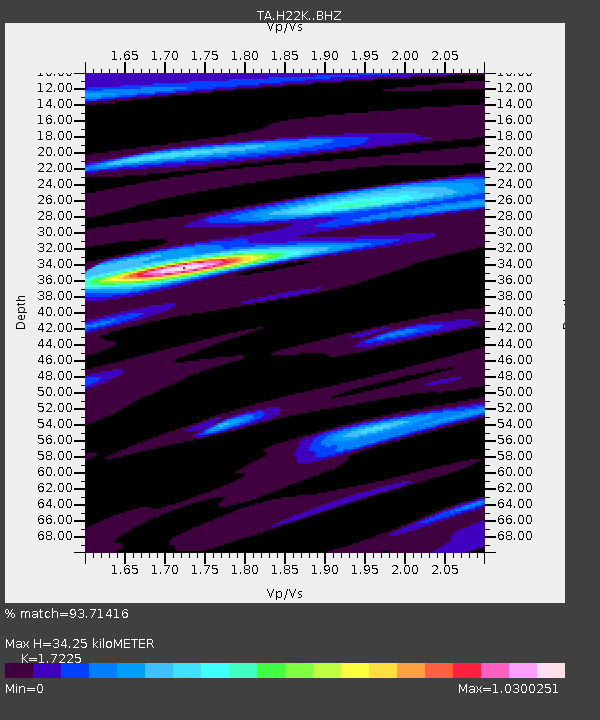
| Estimated Moho Depth: |
34.25 km |
| Estimated Crust Vp/Vs: |
1.72 |
| Assumed Crust Vp: |
6.566 km/s |
| Estimated Crust Vs: |
3.812 km/s |
| Estimated Crust Poisson's Ratio: |
0.25 |
|
| Radial Match: |
93.71416 % |
| Radial Bump: |
400 |
| Transverse Match: |
79.434006 % |
| Transverse Bump: |
400 |
| SOD ConfigId: |
18252611 |
| Insert Time: |
2019-05-07 20:20:27.752 +0000 |
| GWidth: |
2.5 |
| Max Bumps: |
400 |
| Tol: |
0.001 |
|

Signal To Noise
| Channel | StoN | STA | LTA |
| TA:H22K: :BHZ:20190423T20:26:51.475021Z | 12.558419 | 8.2567124E-7 | 6.5746434E-8 |
| TA:H22K: :BHN:20190423T20:26:51.475021Z | 4.601111 | 2.1467758E-7 | 4.665777E-8 |
| TA:H22K: :BHE:20190423T20:26:51.475021Z | 4.5153103 | 2.9649672E-7 | 6.566475E-8 |
| Arrivals |
| Ps | 3.9 SECOND |
| PpPs | 14 SECOND |
| PsPs/PpSs | 18 SECOND |


