You are here: Home > Network List > TA - USArray Transportable Network (new EarthScope stations) Stations List
> Station J19K Poorman, AK, USA > Earthquake Result Viewer
J19K Poorman, AK, USA - Earthquake Result Viewer
| Earthquake location: |
Eastern Xizang-India Border Reg. |
| Earthquake latitude/longitude: |
28.4/94.6 |
| Earthquake time(UTC): |
2019/04/23 (113) 20:15:50 GMT |
| Earthquake Depth: |
14 km |
| Earthquake Magnitude: |
5.9 Mww |
| Earthquake Catalog/Contributor: |
NEIC PDE/us |
|
| Network: |
TA USArray Transportable Network (new EarthScope stations) |
| Station: |
J19K Poorman, AK, USA |
| Lat/Lon: |
63.99 N/155.62 W |
| Elevation: |
389 m |
|
| Distance: |
72.9 deg |
| Az: |
25.718 deg |
| Baz: |
299.88 deg |
| Ray Param: |
0.053327367 |
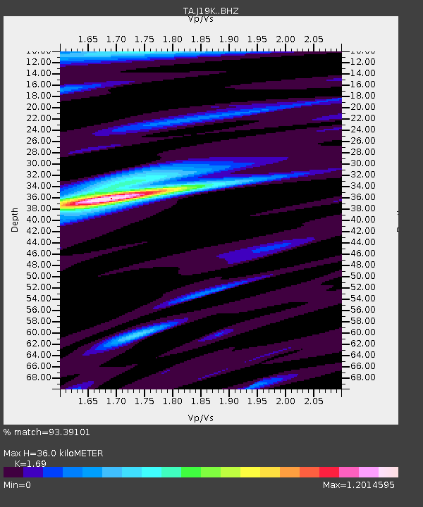
| Estimated Moho Depth: |
36.0 km |
| Estimated Crust Vp/Vs: |
1.69 |
| Assumed Crust Vp: |
6.438 km/s |
| Estimated Crust Vs: |
3.81 km/s |
| Estimated Crust Poisson's Ratio: |
0.23 |
|
| Radial Match: |
93.39101 % |
| Radial Bump: |
400 |
| Transverse Match: |
89.098885 % |
| Transverse Bump: |
400 |
| SOD ConfigId: |
18252611 |
| Insert Time: |
2019-05-07 20:20:38.464 +0000 |
| GWidth: |
2.5 |
| Max Bumps: |
400 |
| Tol: |
0.001 |
|

Signal To Noise
| Channel | StoN | STA | LTA |
| TA:J19K: :BHZ:20190423T20:26:48.249984Z | 12.022303 | 1.085026E-6 | 9.025109E-8 |
| TA:J19K: :BHN:20190423T20:26:48.249984Z | 2.8172996 | 1.3064117E-7 | 4.6371056E-8 |
| TA:J19K: :BHE:20190423T20:26:48.249984Z | 4.5103016 | 3.5682734E-7 | 7.911385E-8 |
| Arrivals |
| Ps | 4.0 SECOND |
| PpPs | 15 SECOND |
| PsPs/PpSs | 19 SECOND |


