You are here: Home > Network List > TA - USArray Transportable Network (new EarthScope stations) Stations List
> Station L17K Donlin, AK, USA > Earthquake Result Viewer
L17K Donlin, AK, USA - Earthquake Result Viewer
| Earthquake location: |
Eastern Xizang-India Border Reg. |
| Earthquake latitude/longitude: |
28.4/94.6 |
| Earthquake time(UTC): |
2019/04/23 (113) 20:15:50 GMT |
| Earthquake Depth: |
14 km |
| Earthquake Magnitude: |
5.9 Mww |
| Earthquake Catalog/Contributor: |
NEIC PDE/us |
|
| Network: |
TA USArray Transportable Network (new EarthScope stations) |
| Station: |
L17K Donlin, AK, USA |
| Lat/Lon: |
62.13 N/158.30 W |
| Elevation: |
338 m |
|
| Distance: |
72.8 deg |
| Az: |
28.045 deg |
| Baz: |
298.183 deg |
| Ray Param: |
0.05343199 |
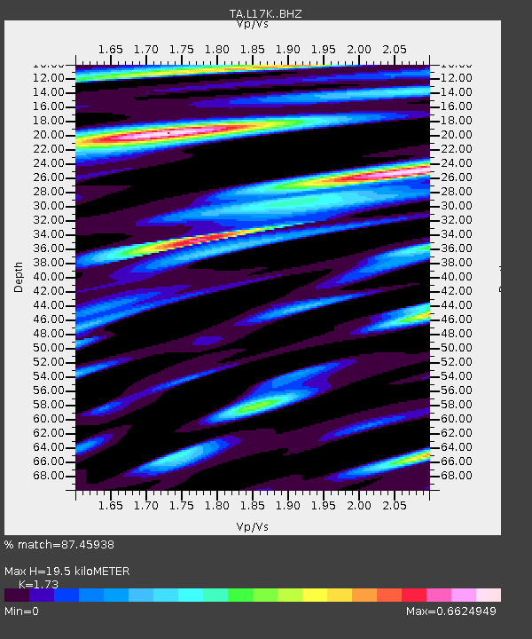
| Estimated Moho Depth: |
19.5 km |
| Estimated Crust Vp/Vs: |
1.73 |
| Assumed Crust Vp: |
6.276 km/s |
| Estimated Crust Vs: |
3.628 km/s |
| Estimated Crust Poisson's Ratio: |
0.25 |
|
| Radial Match: |
87.45938 % |
| Radial Bump: |
400 |
| Transverse Match: |
84.72825 % |
| Transverse Bump: |
400 |
| SOD ConfigId: |
18252611 |
| Insert Time: |
2019-05-07 20:20:48.093 +0000 |
| GWidth: |
2.5 |
| Max Bumps: |
400 |
| Tol: |
0.001 |
|

Signal To Noise
| Channel | StoN | STA | LTA |
| TA:L17K: :BHZ:20190423T20:26:47.299972Z | 13.059198 | 9.541077E-7 | 7.30602E-8 |
| TA:L17K: :BHN:20190423T20:26:47.299972Z | 1.6788186 | 1.9718192E-7 | 1.17452785E-7 |
| TA:L17K: :BHE:20190423T20:26:47.299972Z | 3.167356 | 3.7749192E-7 | 1.19182026E-7 |
| Arrivals |
| Ps | 2.3 SECOND |
| PpPs | 8.2 SECOND |
| PsPs/PpSs | 11 SECOND |


