You are here: Home > Network List > TA - USArray Transportable Network (new EarthScope stations) Stations List
> Station Y16A Circle Bar Ranch, Sunflower, AZ, USA > Earthquake Result Viewer
Y16A Circle Bar Ranch, Sunflower, AZ, USA - Earthquake Result Viewer
| Earthquake location: |
Near Coast Of Northern Chile |
| Earthquake latitude/longitude: |
-23.1/-70.6 |
| Earthquake time(UTC): |
2007/11/17 (321) 17:54:32 GMT |
| Earthquake Depth: |
15 km |
| Earthquake Magnitude: |
5.6 MB, 5.6 MS, 5.8 MW, 5.8 MW |
| Earthquake Catalog/Contributor: |
WHDF/NEIC |
|
| Network: |
TA USArray Transportable Network (new EarthScope stations) |
| Station: |
Y16A Circle Bar Ranch, Sunflower, AZ, USA |
| Lat/Lon: |
33.88 N/111.48 W |
| Elevation: |
1068 m |
|
| Distance: |
68.7 deg |
| Az: |
324.239 deg |
| Baz: |
139.684 deg |
| Ray Param: |
0.0561227 |
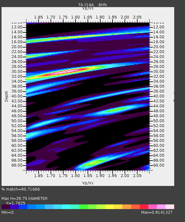
| Estimated Moho Depth: |
29.75 km |
| Estimated Crust Vp/Vs: |
1.76 |
| Assumed Crust Vp: |
6.276 km/s |
| Estimated Crust Vs: |
3.561 km/s |
| Estimated Crust Poisson's Ratio: |
0.26 |
|
| Radial Match: |
90.71686 % |
| Radial Bump: |
395 |
| Transverse Match: |
71.89449 % |
| Transverse Bump: |
400 |
| SOD ConfigId: |
2564 |
| Insert Time: |
2010-03-06 21:44:56.412 +0000 |
| GWidth: |
2.5 |
| Max Bumps: |
400 |
| Tol: |
0.001 |
|

Signal To Noise
| Channel | StoN | STA | LTA |
| TA:Y16A: :BHN:20071117T18:05:04.400005Z | 2.2412057 | 1.5593169E-7 | 6.957491E-8 |
| TA:Y16A: :BHE:20071117T18:05:04.400005Z | 1.2291982 | 1.3193947E-7 | 1.0733784E-7 |
| TA:Y16A: :BHZ:20071117T18:05:04.400005Z | 1.9923832 | 2.722614E-7 | 1.3665111E-7 |
| Arrivals |
| Ps | 3.7 SECOND |
| PpPs | 13 SECOND |
| PsPs/PpSs | 16 SECOND |


