You are here: Home > Network List > TA - USArray Transportable Network (new EarthScope stations) Stations List
> Station Y16A Circle Bar Ranch, Sunflower, AZ, USA > Earthquake Result Viewer
Y16A Circle Bar Ranch, Sunflower, AZ, USA - Earthquake Result Viewer
| Earthquake location: |
Near Coast Of Peru |
| Earthquake latitude/longitude: |
-13.6/-76.6 |
| Earthquake time(UTC): |
2007/08/19 (231) 01:22:40 GMT |
| Earthquake Depth: |
26 km |
| Earthquake Magnitude: |
5.9 MB, 5.4 MS, 5.8 MW, 5.5 ML |
| Earthquake Catalog/Contributor: |
WHDF/NEIC |
|
| Network: |
TA USArray Transportable Network (new EarthScope stations) |
| Station: |
Y16A Circle Bar Ranch, Sunflower, AZ, USA |
| Lat/Lon: |
33.88 N/111.48 W |
| Elevation: |
1068 m |
|
| Distance: |
57.7 deg |
| Az: |
325.782 deg |
| Baz: |
138.916 deg |
| Ray Param: |
0.063258946 |
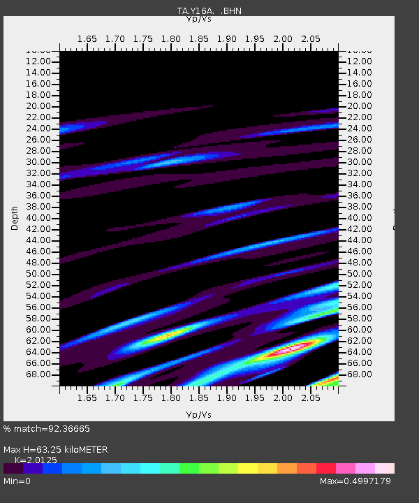
| Estimated Moho Depth: |
63.25 km |
| Estimated Crust Vp/Vs: |
2.01 |
| Assumed Crust Vp: |
6.276 km/s |
| Estimated Crust Vs: |
3.118 km/s |
| Estimated Crust Poisson's Ratio: |
0.34 |
|
| Radial Match: |
92.36665 % |
| Radial Bump: |
274 |
| Transverse Match: |
70.910614 % |
| Transverse Bump: |
400 |
| SOD ConfigId: |
2564 |
| Insert Time: |
2010-03-06 21:45:10.945 +0000 |
| GWidth: |
2.5 |
| Max Bumps: |
400 |
| Tol: |
0.001 |
|
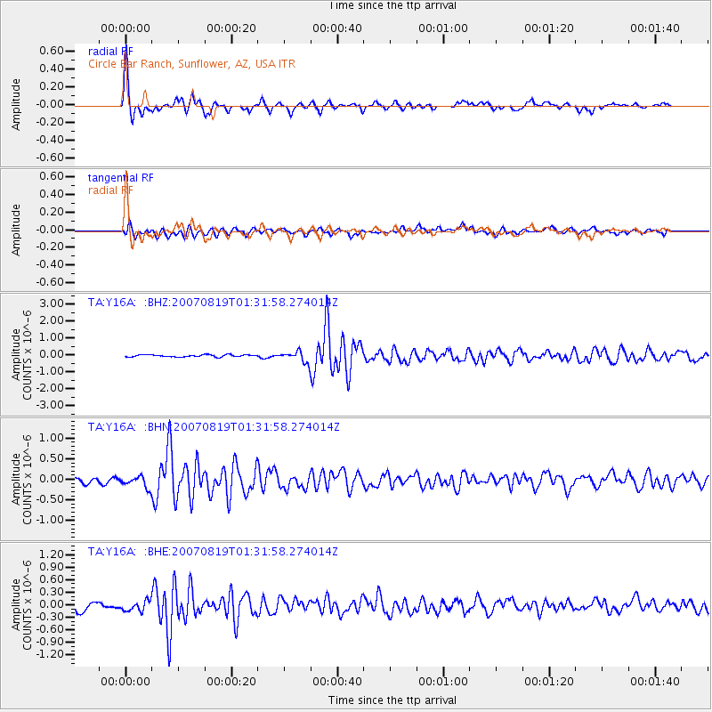
Signal To Noise
| Channel | StoN | STA | LTA |
| TA:Y16A: :BHN:20070819T01:31:58.274014Z | 1.9277967 | 1.461671E-7 | 7.582081E-8 |
| TA:Y16A: :BHE:20070819T01:31:58.274014Z | 1.5125186 | 1.2766051E-7 | 8.440261E-8 |
| TA:Y16A: :BHZ:20070819T01:31:58.274014Z | 5.1879573 | 3.2795967E-7 | 6.3215566E-8 |
| Arrivals |
| Ps | 11 SECOND |
| PpPs | 29 SECOND |
| PsPs/PpSs | 40 SECOND |


