You are here: Home > Network List > TA - USArray Transportable Network (new EarthScope stations) Stations List
> Station Y16A Circle Bar Ranch, Sunflower, AZ, USA > Earthquake Result Viewer
Y16A Circle Bar Ranch, Sunflower, AZ, USA - Earthquake Result Viewer

| Earthquake location: |
Near Coast Of Peru |
| Earthquake latitude/longitude: |
-13.6/-76.6 |
| Earthquake time(UTC): |
2007/08/17 (229) 13:18:13 GMT |
| Earthquake Depth: |
48 km |
| Earthquake Magnitude: |
5.6 MB, 5.6 MS, 5.9 MW |
| Earthquake Catalog/Contributor: |
WHDF/NEIC |
|
| Network: |
TA USArray Transportable Network (new EarthScope stations) |
| Station: |
Y16A Circle Bar Ranch, Sunflower, AZ, USA |
| Lat/Lon: |
33.88 N/111.48 W |
| Elevation: |
1068 m |
|
| Distance: |
57.7 deg |
| Az: |
325.762 deg |
| Baz: |
138.886 deg |
| Ray Param: |
0.06319463 |
| Estimated Moho Depth: |
30.25 km |
| Estimated Crust Vp/Vs: |
1.73 |
| Assumed Crust Vp: |
6.276 km/s |
| Estimated Crust Vs: |
3.633 km/s |
| Estimated Crust Poisson's Ratio: |
0.25 |
|
| Radial Match: |
94.508026 % |
| Radial Bump: |
400 |
| Transverse Match: |
76.00757 % |
| Transverse Bump: |
400 |
| SOD ConfigId: |
2564 |
| Insert Time: |
2010-03-06 21:45:12.103 +0000 |
| GWidth: |
2.5 |
| Max Bumps: |
400 |
| Tol: |
0.001 |
|
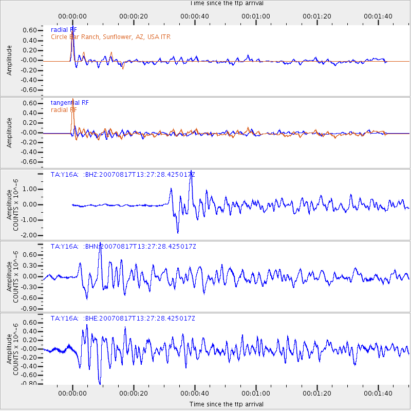
Signal To Noise
| Channel | StoN | STA | LTA |
| TA:Y16A: :BHN:20070817T13:27:28.425017Z | 5.822596 | 2.5081113E-7 | 4.307548E-8 |
| TA:Y16A: :BHE:20070817T13:27:28.425017Z | 8.444141 | 2.5489388E-7 | 3.018588E-8 |
| TA:Y16A: :BHZ:20070817T13:27:28.425017Z | 20.262764 | 7.1541024E-7 | 3.5306645E-8 |
| Arrivals |
| Ps | 3.7 SECOND |
| PpPs | 13 SECOND |
| PsPs/PpSs | 16 SECOND |


