You are here: Home > Network List > TA - USArray Transportable Network (new EarthScope stations) Stations List
> Station Y16A Circle Bar Ranch, Sunflower, AZ, USA > Earthquake Result Viewer
Y16A Circle Bar Ranch, Sunflower, AZ, USA - Earthquake Result Viewer
| Earthquake location: |
Peru-Brazil Border Region |
| Earthquake latitude/longitude: |
-7.9/-74.4 |
| Earthquake time(UTC): |
2007/07/12 (193) 05:23:49 GMT |
| Earthquake Depth: |
152 km |
| Earthquake Magnitude: |
5.9 MB, 6.1 MW, 6.0 MW |
| Earthquake Catalog/Contributor: |
WHDF/NEIC |
|
| Network: |
TA USArray Transportable Network (new EarthScope stations) |
| Station: |
Y16A Circle Bar Ranch, Sunflower, AZ, USA |
| Lat/Lon: |
33.88 N/111.48 W |
| Elevation: |
1068 m |
|
| Distance: |
54.5 deg |
| Az: |
321.927 deg |
| Baz: |
132.756 deg |
| Ray Param: |
0.06492694 |
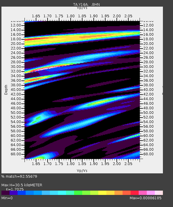
| Estimated Moho Depth: |
30.5 km |
| Estimated Crust Vp/Vs: |
1.70 |
| Assumed Crust Vp: |
6.276 km/s |
| Estimated Crust Vs: |
3.686 km/s |
| Estimated Crust Poisson's Ratio: |
0.24 |
|
| Radial Match: |
92.55679 % |
| Radial Bump: |
400 |
| Transverse Match: |
86.56717 % |
| Transverse Bump: |
400 |
| SOD ConfigId: |
2564 |
| Insert Time: |
2010-03-06 21:45:45.155 +0000 |
| GWidth: |
2.5 |
| Max Bumps: |
400 |
| Tol: |
0.001 |
|
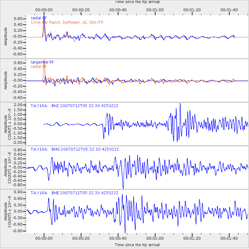
Signal To Noise
| Channel | StoN | STA | LTA |
| TA:Y16A: :BHN:20070712T05:32:30.425022Z | 8.678893 | 2.63652E-7 | 3.037853E-8 |
| TA:Y16A: :BHE:20070712T05:32:30.425022Z | 4.3262506 | 2.581907E-7 | 5.968002E-8 |
| TA:Y16A: :BHZ:20070712T05:32:30.425022Z | 8.319466 | 6.187925E-7 | 7.437888E-8 |
| Arrivals |
| Ps | 3.6 SECOND |
| PpPs | 12 SECOND |
| PsPs/PpSs | 16 SECOND |


