You are here: Home > Network List > TA - USArray Transportable Network (new EarthScope stations) Stations List
> Station Y16A Circle Bar Ranch, Sunflower, AZ, USA > Earthquake Result Viewer
Y16A Circle Bar Ranch, Sunflower, AZ, USA - Earthquake Result Viewer
| Earthquake location: |
Near Coast Of Peru |
| Earthquake latitude/longitude: |
-15.7/-74.9 |
| Earthquake time(UTC): |
2007/06/28 (179) 08:44:48 GMT |
| Earthquake Depth: |
27 km |
| Earthquake Magnitude: |
5.5 MB, 5.3 MS, 5.8 MW, 5.8 MW |
| Earthquake Catalog/Contributor: |
WHDF/NEIC |
|
| Network: |
TA USArray Transportable Network (new EarthScope stations) |
| Station: |
Y16A Circle Bar Ranch, Sunflower, AZ, USA |
| Lat/Lon: |
33.88 N/111.48 W |
| Elevation: |
1068 m |
|
| Distance: |
60.4 deg |
| Az: |
325.217 deg |
| Baz: |
138.663 deg |
| Ray Param: |
0.061533418 |
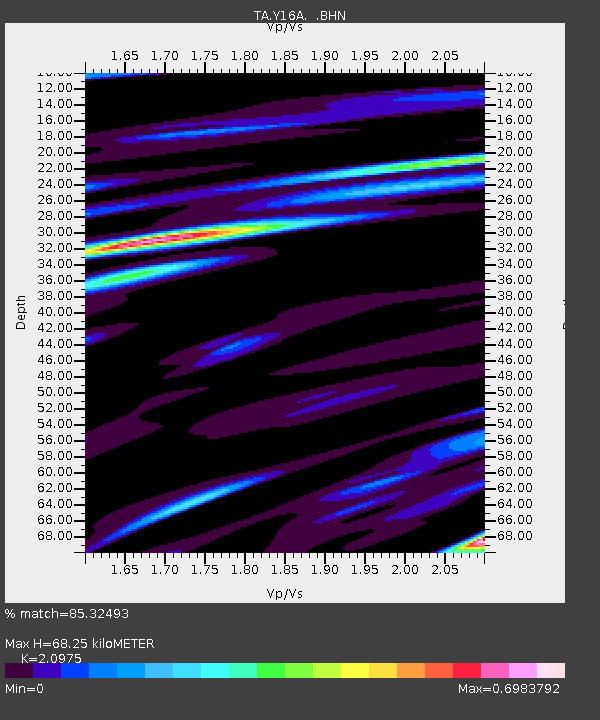
| Estimated Moho Depth: |
68.25 km |
| Estimated Crust Vp/Vs: |
2.10 |
| Assumed Crust Vp: |
6.276 km/s |
| Estimated Crust Vs: |
2.992 km/s |
| Estimated Crust Poisson's Ratio: |
0.35 |
|
| Radial Match: |
85.32493 % |
| Radial Bump: |
380 |
| Transverse Match: |
64.98305 % |
| Transverse Bump: |
400 |
| SOD ConfigId: |
2564 |
| Insert Time: |
2010-03-06 21:45:48.469 +0000 |
| GWidth: |
2.5 |
| Max Bumps: |
400 |
| Tol: |
0.001 |
|
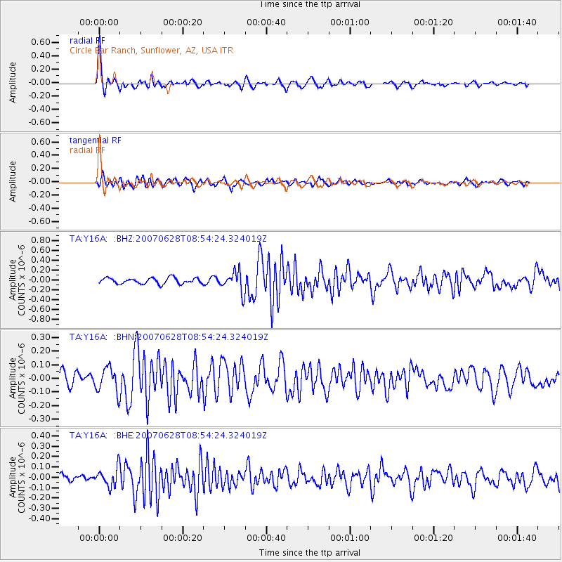
Signal To Noise
| Channel | StoN | STA | LTA |
| TA:Y16A: :BHN:20070628T08:54:24.324019Z | 1.6703604 | 9.321394E-8 | 5.5804687E-8 |
| TA:Y16A: :BHE:20070628T08:54:24.324019Z | 1.8268708 | 9.2378905E-8 | 5.056674E-8 |
| TA:Y16A: :BHZ:20070628T08:54:24.324019Z | 3.6513329 | 2.1605291E-7 | 5.917097E-8 |
| Arrivals |
| Ps | 12 SECOND |
| PpPs | 32 SECOND |
| PsPs/PpSs | 45 SECOND |


