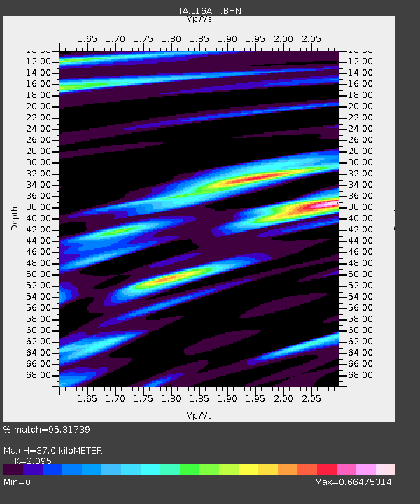
L16A Fish Haven, ID, USA - Earthquake Result Viewer
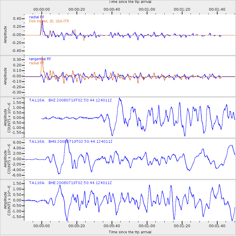
Earthquake location: Off East Coast Of Honshu, Japan
Earthquake latitude/longitude: 37.6/142.2
Earthquake time(UTC): 2008/07/19 (201) 02:39:28 GMT
Earthquake Depth: 22 km
Earthquake Magnitude: 6.2 MB, 7.0 MS, 7.0 MW, 6.9 MW
Earthquake Catalog/Contributor: WHDF/NEIC
Network: TA USArray Transportable Network (new EarthScope stations)
Station: L16A Fish Haven, ID, USA
Lat/Lon: 42.01 N/111.43 W
Elevation: 2013 m
Distance: 76.2 deg
Az: 47.408 deg
Baz: 308.264 deg
Ray Param: 0.051107626
Estimated Moho Depth: 37.0 km
Estimated Crust Vp/Vs: 2.10
Assumed Crust Vp: 6.207 km/s
Estimated Crust Vs: 2.963 km/s
Estimated Crust Poisson's Ratio: 0.35
Radial Match: 95.31739 %
Radial Bump: 400
Transverse Match: 91.207596 %
Transverse Bump: 400
SOD ConfigId: 2504
Insert Time: 2010-03-06 21:47:42.900 +0000
GWidth: 2.5
Max Bumps: 400
Tol: 0.001

Signal To Noise

ChannelStoNSTALTA
TA:L16A: :BHN:20080719T02:50:44.124011Z7.64284754.932552E-76.453814E-8
TA:L16A: :BHE:20080719T02:50:44.124011Z3.2499341.1589909E-73.566198E-8
TA:L16A: :BHZ:20080719T02:50:44.124011Z2.21316841.3869123E-76.266638E-8
Arrivals
Ps6.7 SECOND
PpPs18 SECOND
PsPs/PpSs25 SECOND