You are here: Home > Network List > TA - USArray Transportable Network (new EarthScope stations) Stations List
> Station L16A Fish Haven, ID, USA > Earthquake Result Viewer
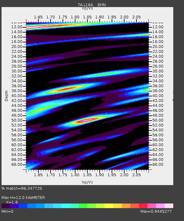
L16A Fish Haven, ID, USA - Earthquake Result Viewer
| Earthquake location: |
Eastern Honshu, Japan |
| Earthquake latitude/longitude: |
39.8/141.5 |
| Earthquake time(UTC): |
2008/07/23 (205) 15:26:19 GMT |
| Earthquake Depth: |
108 km |
| Earthquake Magnitude: |
6.6 MB, 6.8 MW, 6.8 MW |
| Earthquake Catalog/Contributor: |
WHDF/NEIC |
|
| Network: |
TA USArray Transportable Network (new EarthScope stations) |
| Station: |
L16A Fish Haven, ID, USA |
| Lat/Lon: |
42.01 N/111.43 W |
| Elevation: |
2013 m |
|
| Distance: |
75.1 deg |
| Az: |
47.465 deg |
| Baz: |
310.381 deg |
| Ray Param: |
0.051606003 |
| Estimated Moho Depth: |
12.0 km |
| Estimated Crust Vp/Vs: |
1.60 |
| Assumed Crust Vp: |
6.207 km/s |
| Estimated Crust Vs: |
3.879 km/s |
| Estimated Crust Poisson's Ratio: |
0.18 |
|
| Radial Match: |
96.347725 % |
| Radial Bump: |
400 |
| Transverse Match: |
95.897736 % |
| Transverse Bump: |
380 |
| SOD ConfigId: |
2504 |
| Insert Time: |
2010-03-06 21:47:49.224 +0000 |
| GWidth: |
2.5 |
| Max Bumps: |
400 |
| Tol: |
0.001 |
|

Signal To Noise
| Channel | StoN | STA | LTA |
| TA:L16A: :BHN:20080723T15:37:19.450Z | 28.840021 | 2.975088E-6 | 1.0315831E-7 |
| TA:L16A: :BHE:20080723T15:37:19.450Z | 8.111919 | 6.4424756E-7 | 7.941986E-8 |
| TA:L16A: :BHZ:20080723T15:37:19.450Z | 12.239441 | 7.9006435E-7 | 6.455069E-8 |
| Arrivals |
| Ps | 1.2 SECOND |
| PpPs | 4.9 SECOND |
| PsPs/PpSs | 6.1 SECOND |


