L16A Fish Haven, ID, USA - Earthquake Result Viewer
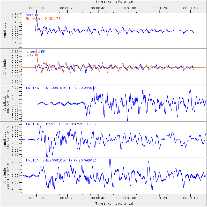
Earthquake location: Near Coast Of Chiapas, Mexico
Earthquake latitude/longitude: 14.4/-92.4
Earthquake time(UTC): 2008/10/16 (290) 19:41:25 GMT
Earthquake Depth: 24 km
Earthquake Magnitude: 6.1 MB, 6.6 MS, 6.7 MW, 6.6 MW
Earthquake Catalog/Contributor: WHDF/NEIC
Network: TA USArray Transportable Network (new EarthScope stations)
Station: L16A Fish Haven, ID, USA
Lat/Lon: 42.01 N/111.43 W
Elevation: 2013 m
Distance: 32.1 deg
Az: 332.704 deg
Baz: 143.4 deg
Ray Param: 0.078781605
Estimated Moho Depth: 46.0 km
Estimated Crust Vp/Vs: 1.79
Assumed Crust Vp: 6.207 km/s
Estimated Crust Vs: 3.477 km/s
Estimated Crust Poisson's Ratio: 0.27
Radial Match: 88.27007 %
Radial Bump: 400
Transverse Match: 77.55049 %
Transverse Bump: 400
SOD ConfigId: 2556
Insert Time: 2010-03-06 21:47:59.055 +0000
GWidth: 2.5
Max Bumps: 400
Tol: 0.001

Signal To Noise

ChannelStoNSTALTA
TA:L16A: :BHN:20081016T19:47:20.04901Z27.4433363.2774071E-61.1942451E-7
TA:L16A: :BHE:20081016T19:47:20.04901Z10.3009921.5070677E-61.4630315E-7
TA:L16A: :BHZ:20081016T19:47:20.04901Z6.8039951.4329279E-62.1060094E-7
Arrivals
Ps6.3 SECOND
PpPs19 SECOND
PsPs/PpSs25 SECOND