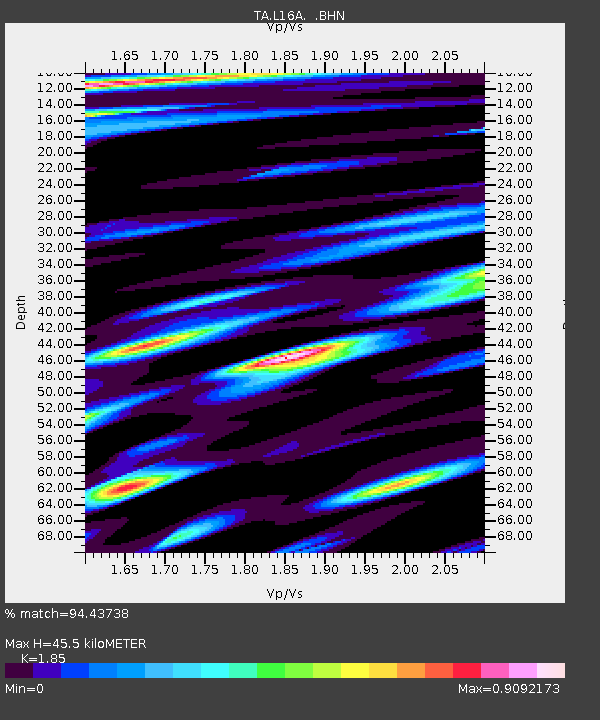
L16A Fish Haven, ID, USA - Earthquake Result Viewer

Earthquake location: Kermadec Islands, New Zealand
Earthquake latitude/longitude: -29.8/-177.7
Earthquake time(UTC): 2008/09/29 (273) 15:19:31 GMT
Earthquake Depth: 36 km
Earthquake Magnitude: 6.5 MB, 6.7 MS, 7.0 MW, 7.0 MW
Earthquake Catalog/Contributor: WHDF/NEIC
Network: TA USArray Transportable Network (new EarthScope stations)
Station: L16A Fish Haven, ID, USA
Lat/Lon: 42.01 N/111.43 W
Elevation: 2013 m
Distance: 93.9 deg
Az: 43.133 deg
Baz: 232.921 deg
Ray Param: 0.041149765
Estimated Moho Depth: 45.5 km
Estimated Crust Vp/Vs: 1.85
Assumed Crust Vp: 6.207 km/s
Estimated Crust Vs: 3.355 km/s
Estimated Crust Poisson's Ratio: 0.29
Radial Match: 94.43738 %
Radial Bump: 400
Transverse Match: 90.107 %
Transverse Bump: 400
SOD ConfigId: 2560
Insert Time: 2010-03-06 21:48:21.425 +0000
GWidth: 2.5
Max Bumps: 400
Tol: 0.001

Signal To Noise

ChannelStoNSTALTA
TA:L16A: :BHN:20080929T15:32:14.123997Z11.0622835.5837126E-75.047523E-8
TA:L16A: :BHE:20080929T15:32:14.123997Z1.91590271.5584281E-78.134172E-8
TA:L16A: :BHZ:20080929T15:32:14.123997Z1.14460937.943912E-86.940282E-8
Arrivals
Ps6.3 SECOND
PpPs21 SECOND
PsPs/PpSs27 SECOND