You are here: Home > Network List > TA - USArray Transportable Network (new EarthScope stations) Stations List
> Station L16A Fish Haven, ID, USA > Earthquake Result Viewer
L16A Fish Haven, ID, USA - Earthquake Result Viewer
| Earthquake location: |
East Of Kuril Islands |
| Earthquake latitude/longitude: |
46.9/155.2 |
| Earthquake time(UTC): |
2009/01/15 (015) 17:49:39 GMT |
| Earthquake Depth: |
36 km |
| Earthquake Magnitude: |
6.9 MB, 7.5 MS, 7.4 MW, 7.4 MW |
| Earthquake Catalog/Contributor: |
WHDF/NEIC |
|
| Network: |
TA USArray Transportable Network (new EarthScope stations) |
| Station: |
L16A Fish Haven, ID, USA |
| Lat/Lon: |
42.01 N/111.43 W |
| Elevation: |
2013 m |
|
| Distance: |
63.0 deg |
| Az: |
56.632 deg |
| Baz: |
309.727 deg |
| Ray Param: |
0.059822746 |
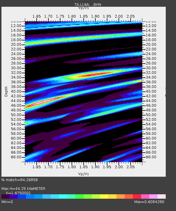
| Estimated Moho Depth: |
44.25 km |
| Estimated Crust Vp/Vs: |
1.68 |
| Assumed Crust Vp: |
6.207 km/s |
| Estimated Crust Vs: |
3.706 km/s |
| Estimated Crust Poisson's Ratio: |
0.22 |
|
| Radial Match: |
94.26959 % |
| Radial Bump: |
325 |
| Transverse Match: |
95.54166 % |
| Transverse Bump: |
304 |
| SOD ConfigId: |
2658 |
| Insert Time: |
2010-03-06 21:48:46.920 +0000 |
| GWidth: |
2.5 |
| Max Bumps: |
400 |
| Tol: |
0.001 |
|

Signal To Noise
| Channel | StoN | STA | LTA |
| TA:L16A: :BHN:20090115T17:59:31.275017Z | 41.757744 | 1.1540213E-5 | 2.7636102E-7 |
| TA:L16A: :BHE:20090115T17:59:31.275017Z | 12.057069 | 3.2406742E-6 | 2.6877794E-7 |
| TA:L16A: :BHZ:20090115T17:59:31.275017Z | 13.860166 | 3.8618696E-6 | 2.7863084E-7 |
| Arrivals |
| Ps | 5.0 SECOND |
| PpPs | 18 SECOND |
| PsPs/PpSs | 23 SECOND |


