You are here: Home > Network List > TA - USArray Transportable Network (new EarthScope stations) Stations List
> Station L16A Fish Haven, ID, USA > Earthquake Result Viewer
L16A Fish Haven, ID, USA - Earthquake Result Viewer
| Earthquake location: |
Mariana Islands |
| Earthquake latitude/longitude: |
18.9/145.4 |
| Earthquake time(UTC): |
2007/10/31 (304) 03:30:17 GMT |
| Earthquake Depth: |
223 km |
| Earthquake Magnitude: |
6.2 MB, 7.2 MW, 7.2 MW |
| Earthquake Catalog/Contributor: |
WHDF/NEIC |
|
| Network: |
TA USArray Transportable Network (new EarthScope stations) |
| Station: |
L16A Fish Haven, ID, USA |
| Lat/Lon: |
42.01 N/111.43 W |
| Elevation: |
2013 m |
|
| Distance: |
86.9 deg |
| Az: |
46.597 deg |
| Baz: |
292.623 deg |
| Ray Param: |
0.04316513 |
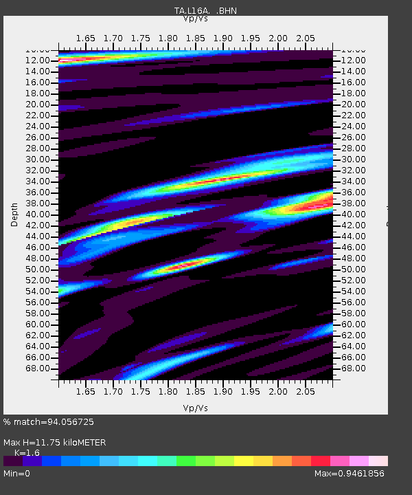
| Estimated Moho Depth: |
11.75 km |
| Estimated Crust Vp/Vs: |
1.60 |
| Assumed Crust Vp: |
6.207 km/s |
| Estimated Crust Vs: |
3.879 km/s |
| Estimated Crust Poisson's Ratio: |
0.18 |
|
| Radial Match: |
94.056725 % |
| Radial Bump: |
400 |
| Transverse Match: |
81.62905 % |
| Transverse Bump: |
400 |
| SOD ConfigId: |
2564 |
| Insert Time: |
2010-03-06 21:49:16.478 +0000 |
| GWidth: |
2.5 |
| Max Bumps: |
400 |
| Tol: |
0.001 |
|
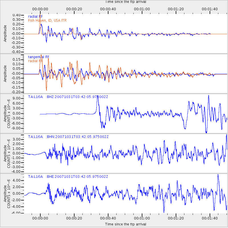
Signal To Noise
| Channel | StoN | STA | LTA |
| TA:L16A: :BHN:20071031T03:42:05.975002Z | 3.4346154 | 4.2038036E-7 | 1.2239518E-7 |
| TA:L16A: :BHE:20071031T03:42:05.975002Z | 3.4142056 | 9.4636414E-7 | 2.7718428E-7 |
| TA:L16A: :BHZ:20071031T03:42:05.975002Z | 21.20908 | 4.357486E-6 | 2.054538E-7 |
| Arrivals |
| Ps | 1.2 SECOND |
| PpPs | 4.8 SECOND |
| PsPs/PpSs | 6.0 SECOND |


