You are here: Home > Network List > TA - USArray Transportable Network (new EarthScope stations) Stations List
> Station L16A Fish Haven, ID, USA > Earthquake Result Viewer
L16A Fish Haven, ID, USA - Earthquake Result Viewer
| Earthquake location: |
South Of Fiji Islands |
| Earthquake latitude/longitude: |
-25.8/179.5 |
| Earthquake time(UTC): |
2007/10/16 (289) 21:05:43 GMT |
| Earthquake Depth: |
509 km |
| Earthquake Magnitude: |
6.2 MB, 6.6 MW, 6.5 MW |
| Earthquake Catalog/Contributor: |
WHDF/NEIC |
|
| Network: |
TA USArray Transportable Network (new EarthScope stations) |
| Station: |
L16A Fish Haven, ID, USA |
| Lat/Lon: |
42.01 N/111.43 W |
| Elevation: |
2013 m |
|
| Distance: |
92.8 deg |
| Az: |
44.162 deg |
| Baz: |
237.453 deg |
| Ray Param: |
0.041004963 |
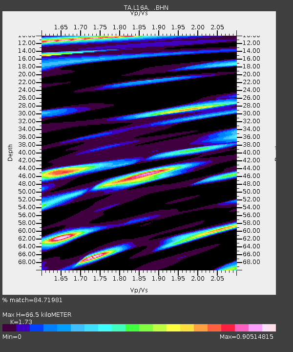
| Estimated Moho Depth: |
66.5 km |
| Estimated Crust Vp/Vs: |
1.73 |
| Assumed Crust Vp: |
6.207 km/s |
| Estimated Crust Vs: |
3.588 km/s |
| Estimated Crust Poisson's Ratio: |
0.25 |
|
| Radial Match: |
84.71981 % |
| Radial Bump: |
400 |
| Transverse Match: |
84.63585 % |
| Transverse Bump: |
400 |
| SOD ConfigId: |
2564 |
| Insert Time: |
2010-03-06 21:49:19.051 +0000 |
| GWidth: |
2.5 |
| Max Bumps: |
400 |
| Tol: |
0.001 |
|

Signal To Noise
| Channel | StoN | STA | LTA |
| TA:L16A: :BHN:20071016T21:17:29.324016Z | 4.2800374 | 4.1869924E-7 | 9.782607E-8 |
| TA:L16A: :BHE:20071016T21:17:29.324016Z | 2.9358912 | 3.7505964E-7 | 1.2774984E-7 |
| TA:L16A: :BHZ:20071016T21:17:29.324016Z | 25.881159 | 2.1551768E-6 | 8.327204E-8 |
| Arrivals |
| Ps | 8.0 SECOND |
| PpPs | 29 SECOND |
| PsPs/PpSs | 37 SECOND |


