You are here: Home > Network List > TA - USArray Transportable Network (new EarthScope stations) Stations List
> Station L16A Fish Haven, ID, USA > Earthquake Result Viewer
L16A Fish Haven, ID, USA - Earthquake Result Viewer
| Earthquake location: |
Vanuatu Islands |
| Earthquake latitude/longitude: |
-15.4/168.6 |
| Earthquake time(UTC): |
2007/07/15 (196) 09:27:34 GMT |
| Earthquake Depth: |
8.0 km |
| Earthquake Magnitude: |
6.0 MB, 5.8 MS, 6.1 MW, 6.0 MW |
| Earthquake Catalog/Contributor: |
WHDF/NEIC |
|
| Network: |
TA USArray Transportable Network (new EarthScope stations) |
| Station: |
L16A Fish Haven, ID, USA |
| Lat/Lon: |
42.01 N/111.43 W |
| Elevation: |
2013 m |
|
| Distance: |
92.9 deg |
| Az: |
47.287 deg |
| Baz: |
252.009 deg |
| Ray Param: |
0.04136782 |
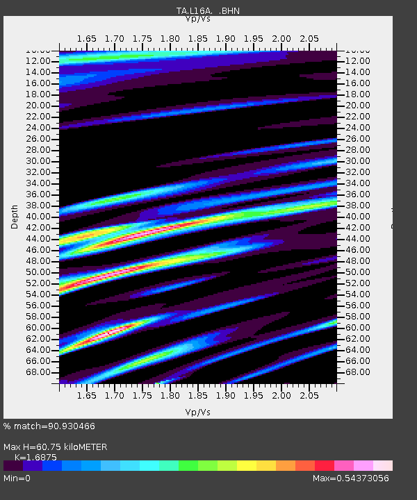
| Estimated Moho Depth: |
60.75 km |
| Estimated Crust Vp/Vs: |
1.69 |
| Assumed Crust Vp: |
6.207 km/s |
| Estimated Crust Vs: |
3.678 km/s |
| Estimated Crust Poisson's Ratio: |
0.23 |
|
| Radial Match: |
90.930466 % |
| Radial Bump: |
400 |
| Transverse Match: |
84.736984 % |
| Transverse Bump: |
400 |
| SOD ConfigId: |
2564 |
| Insert Time: |
2010-03-06 21:50:05.264 +0000 |
| GWidth: |
2.5 |
| Max Bumps: |
400 |
| Tol: |
0.001 |
|

Signal To Noise
| Channel | StoN | STA | LTA |
| TA:L16A: :BHN:20070715T09:40:16.224019Z | 2.5745306 | 1.2400297E-7 | 4.8165276E-8 |
| TA:L16A: :BHE:20070715T09:40:16.224019Z | 5.1644373 | 1.9046236E-7 | 3.6879594E-8 |
| TA:L16A: :BHZ:20070715T09:40:16.224019Z | 22.665558 | 9.213359E-7 | 4.0649162E-8 |
| Arrivals |
| Ps | 6.9 SECOND |
| PpPs | 26 SECOND |
| PsPs/PpSs | 33 SECOND |


