You are here: Home > Network List > CN - Canadian National Seismograph Network Stations List
> Station INK INUVIK, NT > Earthquake Result Viewer
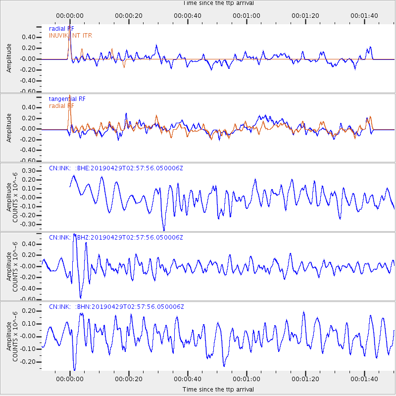
INK INUVIK, NT - Earthquake Result Viewer
*The percent match for this event was below the threshold and hence no stack was calculated.
| Earthquake location: |
Northern Mid-Atlantic Ridge |
| Earthquake latitude/longitude: |
43.2/-29.1 |
| Earthquake time(UTC): |
2019/04/29 (119) 02:48:51 GMT |
| Earthquake Depth: |
10 km |
| Earthquake Magnitude: |
5.5 Mww |
| Earthquake Catalog/Contributor: |
NEIC PDE/us |
|
| Network: |
CN Canadian National Seismograph Network |
| Station: |
INK INUVIK, NT |
| Lat/Lon: |
68.31 N/133.53 W |
| Elevation: |
44 m |
|
| Distance: |
55.6 deg |
| Az: |
334.116 deg |
| Baz: |
59.198 deg |
| Ray Param: |
$rayparam |
*The percent match for this event was below the threshold and hence was not used in the summary stack. |
|
| Radial Match: |
69.70501 % |
| Radial Bump: |
400 |
| Transverse Match: |
51.736893 % |
| Transverse Bump: |
400 |
| SOD ConfigId: |
18252611 |
| Insert Time: |
2019-05-13 02:51:23.526 +0000 |
| GWidth: |
2.5 |
| Max Bumps: |
400 |
| Tol: |
0.001 |
|
Signal To Noise
| Channel | StoN | STA | LTA |
| CN:INK: :BHZ:20190429T02:57:56.050006Z | 5.771474 | 3.536954E-7 | 6.128337E-8 |
| CN:INK: :BHN:20190429T02:57:56.050006Z | 1.7077032 | 1.5812923E-7 | 9.25976E-8 |
| CN:INK: :BHE:20190429T02:57:56.050006Z | 1.6836222 | 1.7913563E-7 | 1.0639895E-7 |
| Arrivals |
| Ps | |
| PpPs | |
| PsPs/PpSs | |


