You are here: Home > Network List > TA - USArray Transportable Network (new EarthScope stations) Stations List
> Station L16A Fish Haven, ID, USA > Earthquake Result Viewer
L16A Fish Haven, ID, USA - Earthquake Result Viewer
| Earthquake location: |
Solomon Islands |
| Earthquake latitude/longitude: |
-10.5/161.3 |
| Earthquake time(UTC): |
2008/06/03 (155) 16:20:50 GMT |
| Earthquake Depth: |
84 km |
| Earthquake Magnitude: |
6.2 MB, 6.2 MW, 6.2 MW |
| Earthquake Catalog/Contributor: |
WHDF/NEIC |
|
| Network: |
TA USArray Transportable Network (new EarthScope stations) |
| Station: |
L16A Fish Haven, ID, USA |
| Lat/Lon: |
42.01 N/111.43 W |
| Elevation: |
2013 m |
|
| Distance: |
94.9 deg |
| Az: |
48.345 deg |
| Baz: |
260.409 deg |
| Ray Param: |
0.04085511 |
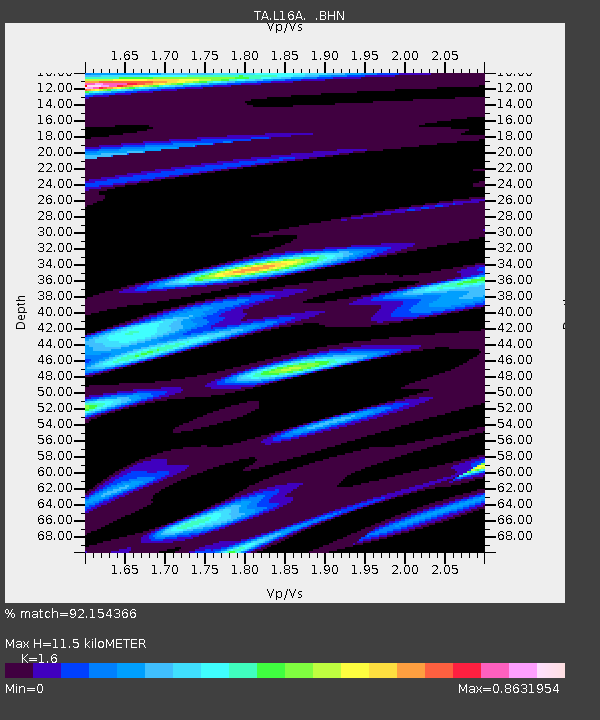
| Estimated Moho Depth: |
11.5 km |
| Estimated Crust Vp/Vs: |
1.60 |
| Assumed Crust Vp: |
6.207 km/s |
| Estimated Crust Vs: |
3.879 km/s |
| Estimated Crust Poisson's Ratio: |
0.18 |
|
| Radial Match: |
92.154366 % |
| Radial Bump: |
400 |
| Transverse Match: |
88.85403 % |
| Transverse Bump: |
400 |
| SOD ConfigId: |
2504 |
| Insert Time: |
2010-03-06 21:50:19.747 +0000 |
| GWidth: |
2.5 |
| Max Bumps: |
400 |
| Tol: |
0.001 |
|

Signal To Noise
| Channel | StoN | STA | LTA |
| TA:L16A: :BHN:20080603T16:33:32.02502Z | 15.146176 | 7.571161E-7 | 4.9987275E-8 |
| TA:L16A: :BHE:20080603T16:33:32.02502Z | 1.1346295 | 5.644685E-8 | 4.9749147E-8 |
| TA:L16A: :BHZ:20080603T16:33:32.02502Z | 4.152825 | 1.4898689E-7 | 3.587603E-8 |
| Arrivals |
| Ps | 1.1 SECOND |
| PpPs | 4.7 SECOND |
| PsPs/PpSs | 5.9 SECOND |


