You are here: Home > Network List > TA - USArray Transportable Network (new EarthScope stations) Stations List
> Station L16A Fish Haven, ID, USA > Earthquake Result Viewer
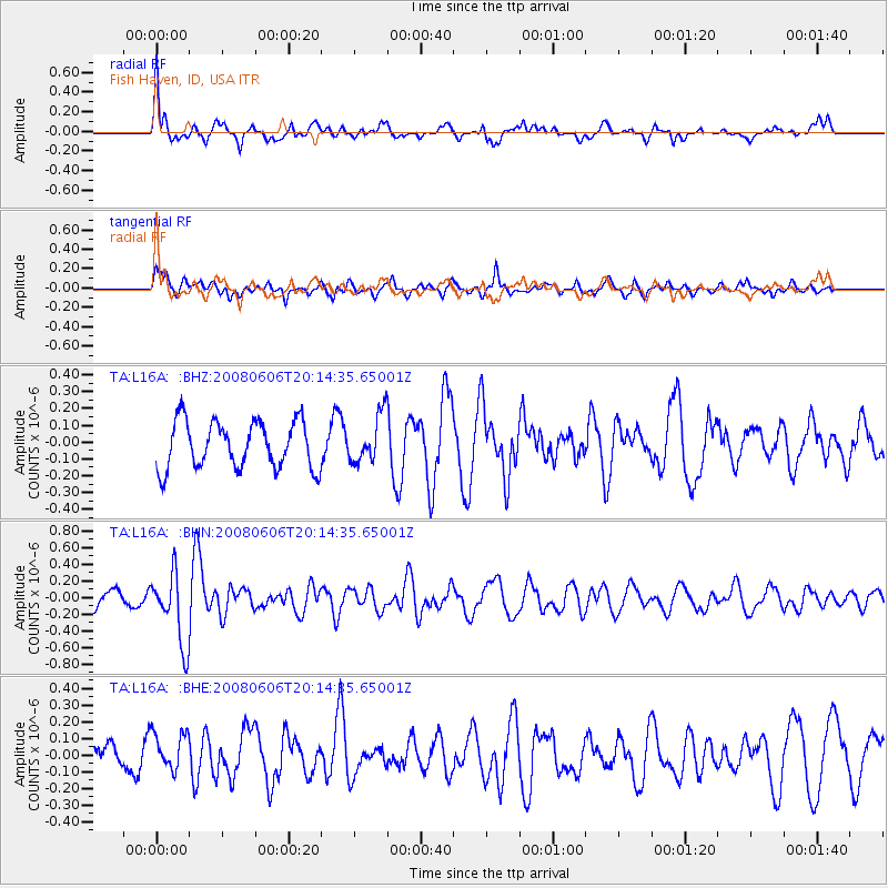
L16A Fish Haven, ID, USA - Earthquake Result Viewer
*The percent match for this event was below the threshold and hence no stack was calculated.
| Earthquake location: |
Northern Algeria |
| Earthquake latitude/longitude: |
35.9/-0.7 |
| Earthquake time(UTC): |
2008/06/06 (158) 20:02:56 GMT |
| Earthquake Depth: |
4.0 km |
| Earthquake Magnitude: |
5.5 MB, 5.3 MS, 5.5 MW, 5.5 MW |
| Earthquake Catalog/Contributor: |
WHDF/NEIC |
|
| Network: |
TA USArray Transportable Network (new EarthScope stations) |
| Station: |
L16A Fish Haven, ID, USA |
| Lat/Lon: |
42.01 N/111.43 W |
| Elevation: |
2013 m |
|
| Distance: |
80.0 deg |
| Az: |
314.959 deg |
| Baz: |
50.454 deg |
| Ray Param: |
$rayparam |
*The percent match for this event was below the threshold and hence was not used in the summary stack. |
|
| Radial Match: |
55.550766 % |
| Radial Bump: |
387 |
| Transverse Match: |
68.73411 % |
| Transverse Bump: |
400 |
| SOD ConfigId: |
2504 |
| Insert Time: |
2010-03-06 21:50:42.335 +0000 |
| GWidth: |
2.5 |
| Max Bumps: |
400 |
| Tol: |
0.001 |
|
Signal To Noise
| Channel | StoN | STA | LTA |
| TA:L16A: :BHN:20080606T20:14:35.65001Z | 4.0131683 | 4.2739188E-7 | 1.06497374E-7 |
| TA:L16A: :BHE:20080606T20:14:35.65001Z | 2.036144 | 1.14910996E-7 | 5.6435596E-8 |
| TA:L16A: :BHZ:20080606T20:14:35.65001Z | 1.0309207 | 1.4351065E-7 | 1.3920629E-7 |
| Arrivals |
| Ps | |
| PpPs | |
| PsPs/PpSs | |


