You are here: Home > Network List > TA - USArray Transportable Network (new EarthScope stations) Stations List
> Station L16A Fish Haven, ID, USA > Earthquake Result Viewer
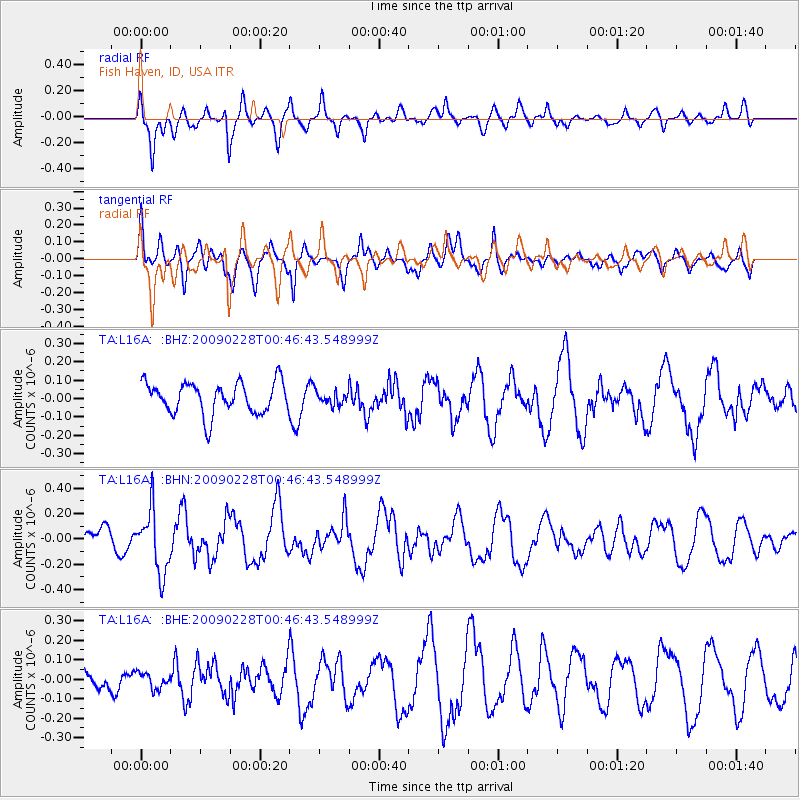
L16A Fish Haven, ID, USA - Earthquake Result Viewer
*The percent match for this event was below the threshold and hence no stack was calculated.
| Earthquake location: |
Hokkaido, Japan Region |
| Earthquake latitude/longitude: |
42.6/142.1 |
| Earthquake time(UTC): |
2009/02/28 (059) 00:35:56 GMT |
| Earthquake Depth: |
105 km |
| Earthquake Magnitude: |
5.5 MB, 5.5 MW, 5.5 MW |
| Earthquake Catalog/Contributor: |
WHDF/NEIC |
|
| Network: |
TA USArray Transportable Network (new EarthScope stations) |
| Station: |
L16A Fish Haven, ID, USA |
| Lat/Lon: |
42.01 N/111.43 W |
| Elevation: |
2013 m |
|
| Distance: |
72.9 deg |
| Az: |
48.388 deg |
| Baz: |
312.211 deg |
| Ray Param: |
$rayparam |
*The percent match for this event was below the threshold and hence was not used in the summary stack. |
|
| Radial Match: |
41.759655 % |
| Radial Bump: |
355 |
| Transverse Match: |
58.354454 % |
| Transverse Bump: |
400 |
| SOD ConfigId: |
2658 |
| Insert Time: |
2010-03-06 21:50:59.827 +0000 |
| GWidth: |
2.5 |
| Max Bumps: |
400 |
| Tol: |
0.001 |
|
Signal To Noise
| Channel | StoN | STA | LTA |
| TA:L16A: :BHN:20090228T00:46:43.548999Z | 2.339491 | 2.46877E-7 | 1.0552595E-7 |
| TA:L16A: :BHE:20090228T00:46:43.548999Z | 0.25177622 | 3.9712532E-8 | 1.5772949E-7 |
| TA:L16A: :BHZ:20090228T00:46:43.548999Z | 0.4176243 | 3.559825E-8 | 8.52399E-8 |
| Arrivals |
| Ps | |
| PpPs | |
| PsPs/PpSs | |


