You are here: Home > Network List > TA - USArray Transportable Network (new EarthScope stations) Stations List
> Station L16A Fish Haven, ID, USA > Earthquake Result Viewer
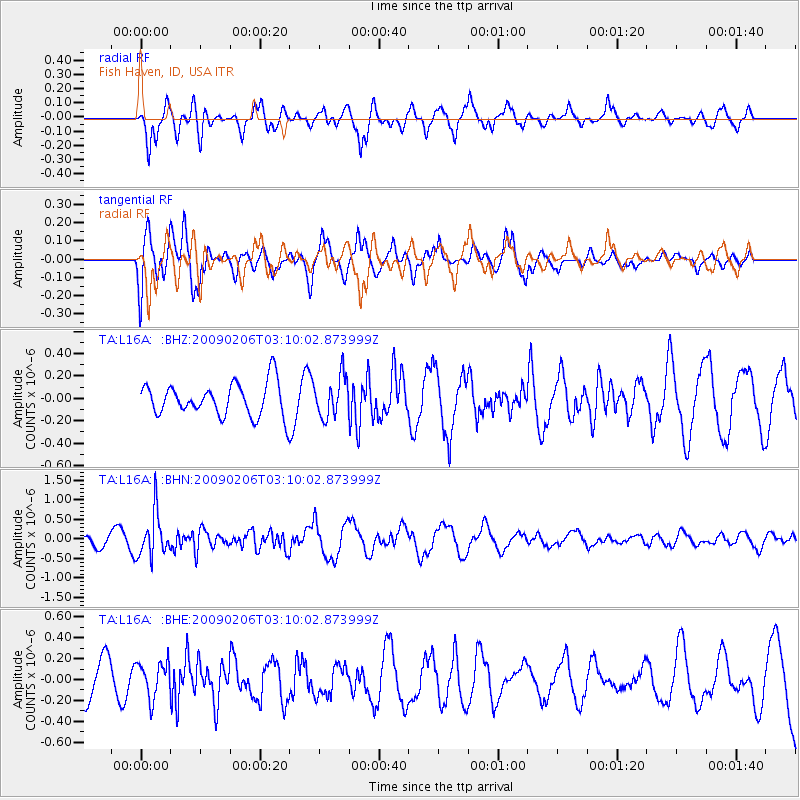
L16A Fish Haven, ID, USA - Earthquake Result Viewer
*The percent match for this event was below the threshold and hence no stack was calculated.
| Earthquake location: |
Near Coast Of Northern Chile |
| Earthquake latitude/longitude: |
-28.0/-71.1 |
| Earthquake time(UTC): |
2009/02/06 (037) 02:58:35 GMT |
| Earthquake Depth: |
52 km |
| Earthquake Magnitude: |
5.5 MB |
| Earthquake Catalog/Contributor: |
WHDF/NEIC |
|
| Network: |
TA USArray Transportable Network (new EarthScope stations) |
| Station: |
L16A Fish Haven, ID, USA |
| Lat/Lon: |
42.01 N/111.43 W |
| Elevation: |
2013 m |
|
| Distance: |
79.0 deg |
| Az: |
330.573 deg |
| Baz: |
144.333 deg |
| Ray Param: |
$rayparam |
*The percent match for this event was below the threshold and hence was not used in the summary stack. |
|
| Radial Match: |
67.53744 % |
| Radial Bump: |
374 |
| Transverse Match: |
63.613224 % |
| Transverse Bump: |
400 |
| SOD ConfigId: |
2658 |
| Insert Time: |
2010-03-06 21:51:30.280 +0000 |
| GWidth: |
2.5 |
| Max Bumps: |
400 |
| Tol: |
0.001 |
|
Signal To Noise
| Channel | StoN | STA | LTA |
| TA:L16A: :BHN:20090206T03:10:02.873999Z | 3.2488134 | 5.585629E-7 | 1.7192826E-7 |
| TA:L16A: :BHE:20090206T03:10:02.873999Z | 1.0128169 | 1.7123074E-7 | 1.6906385E-7 |
| TA:L16A: :BHZ:20090206T03:10:02.873999Z | 1.2048067 | 1.7736163E-7 | 1.472117E-7 |
| Arrivals |
| Ps | |
| PpPs | |
| PsPs/PpSs | |


