You are here: Home > Network List > TA - USArray Transportable Network (new EarthScope stations) Stations List
> Station L16A Fish Haven, ID, USA > Earthquake Result Viewer
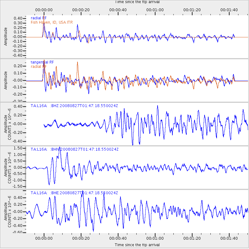
L16A Fish Haven, ID, USA - Earthquake Result Viewer
*The percent match for this event was below the threshold and hence no stack was calculated.
| Earthquake location: |
Lake Baykal Region, Russia |
| Earthquake latitude/longitude: |
51.6/104.2 |
| Earthquake time(UTC): |
2008/08/27 (240) 01:35:32 GMT |
| Earthquake Depth: |
16 km |
| Earthquake Magnitude: |
5.8 MB, 6.2 MS, 6.2 MW, 6.2 MW |
| Earthquake Catalog/Contributor: |
WHDF/NEIC |
|
| Network: |
TA USArray Transportable Network (new EarthScope stations) |
| Station: |
L16A Fish Haven, ID, USA |
| Lat/Lon: |
42.01 N/111.43 W |
| Elevation: |
2013 m |
|
| Distance: |
81.8 deg |
| Az: |
25.99 deg |
| Baz: |
338.487 deg |
| Ray Param: |
$rayparam |
*The percent match for this event was below the threshold and hence was not used in the summary stack. |
|
| Radial Match: |
85.67615 % |
| Radial Bump: |
400 |
| Transverse Match: |
83.75622 % |
| Transverse Bump: |
400 |
| SOD ConfigId: |
2504 |
| Insert Time: |
2010-03-06 21:51:44.198 +0000 |
| GWidth: |
2.5 |
| Max Bumps: |
400 |
| Tol: |
0.001 |
|
Signal To Noise
| Channel | StoN | STA | LTA |
| TA:L16A: :BHN:20080827T01:47:18.550024Z | 7.902343 | 5.772668E-7 | 7.305008E-8 |
| TA:L16A: :BHE:20080827T01:47:18.550024Z | 2.1173882 | 1.8042829E-7 | 8.521266E-8 |
| TA:L16A: :BHZ:20080827T01:47:18.550024Z | 2.3985813 | 7.969954E-8 | 3.3227785E-8 |
| Arrivals |
| Ps | |
| PpPs | |
| PsPs/PpSs | |


