You are here: Home > Network List > TA - USArray Transportable Network (new EarthScope stations) Stations List
> Station L16A Fish Haven, ID, USA > Earthquake Result Viewer
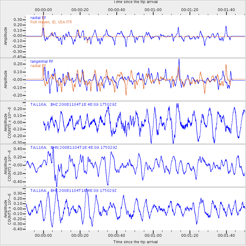
L16A Fish Haven, ID, USA - Earthquake Result Viewer
*The percent match for this event was below the threshold and hence no stack was calculated.
| Earthquake location: |
Vanuatu Islands |
| Earthquake latitude/longitude: |
-17.1/168.5 |
| Earthquake time(UTC): |
2008/11/04 (309) 18:35:45 GMT |
| Earthquake Depth: |
206 km |
| Earthquake Magnitude: |
5.7 MB, 6.3 MW, 6.3 MW |
| Earthquake Catalog/Contributor: |
WHDF/NEIC |
|
| Network: |
TA USArray Transportable Network (new EarthScope stations) |
| Station: |
L16A Fish Haven, ID, USA |
| Lat/Lon: |
42.01 N/111.43 W |
| Elevation: |
2013 m |
|
| Distance: |
94.2 deg |
| Az: |
47.399 deg |
| Baz: |
250.816 deg |
| Ray Param: |
$rayparam |
*The percent match for this event was below the threshold and hence was not used in the summary stack. |
|
| Radial Match: |
51.97719 % |
| Radial Bump: |
333 |
| Transverse Match: |
39.45498 % |
| Transverse Bump: |
374 |
| SOD ConfigId: |
2658 |
| Insert Time: |
2010-03-06 21:51:46.372 +0000 |
| GWidth: |
2.5 |
| Max Bumps: |
400 |
| Tol: |
0.001 |
|
Signal To Noise
| Channel | StoN | STA | LTA |
| TA:L16A: :BHN:20081104T18:48:09.175029Z | 1.8999782 | 1.8512469E-7 | 9.743516E-8 |
| TA:L16A: :BHE:20081104T18:48:09.175029Z | 2.5495343 | 2.0072352E-7 | 7.8729485E-8 |
| TA:L16A: :BHZ:20081104T18:48:09.175029Z | 1.2631251 | 8.6339384E-8 | 6.8353785E-8 |
| Arrivals |
| Ps | |
| PpPs | |
| PsPs/PpSs | |


