You are here: Home > Network List > TA - USArray Transportable Network (new EarthScope stations) Stations List
> Station D23K Nanushuk River, AK USA > Earthquake Result Viewer
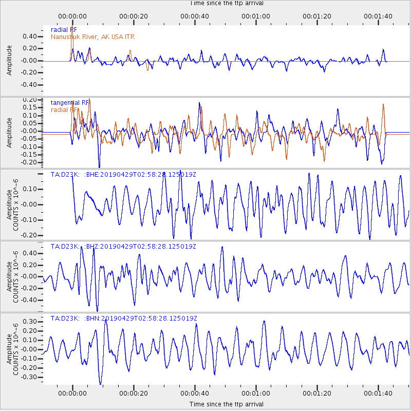
D23K Nanushuk River, AK USA - Earthquake Result Viewer
*The percent match for this event was below the threshold and hence no stack was calculated.
| Earthquake location: |
Northern Mid-Atlantic Ridge |
| Earthquake latitude/longitude: |
43.2/-29.1 |
| Earthquake time(UTC): |
2019/04/29 (119) 02:48:51 GMT |
| Earthquake Depth: |
10 km |
| Earthquake Magnitude: |
5.5 Mww |
| Earthquake Catalog/Contributor: |
NEIC PDE/us |
|
| Network: |
TA USArray Transportable Network (new EarthScope stations) |
| Station: |
D23K Nanushuk River, AK USA |
| Lat/Lon: |
68.97 N/150.68 W |
| Elevation: |
406 m |
|
| Distance: |
60.2 deg |
| Az: |
339.227 deg |
| Baz: |
45.941 deg |
| Ray Param: |
$rayparam |
*The percent match for this event was below the threshold and hence was not used in the summary stack. |
|
| Radial Match: |
51.70819 % |
| Radial Bump: |
400 |
| Transverse Match: |
63.297325 % |
| Transverse Bump: |
400 |
| SOD ConfigId: |
18252611 |
| Insert Time: |
2019-05-13 02:56:46.040 +0000 |
| GWidth: |
2.5 |
| Max Bumps: |
400 |
| Tol: |
0.001 |
|
Signal To Noise
| Channel | StoN | STA | LTA |
| TA:D23K: :BHZ:20190429T02:58:28.125019Z | 1.9223319 | 2.495147E-7 | 1.2979794E-7 |
| TA:D23K: :BHN:20190429T02:58:28.125019Z | 1.2297502 | 1.06246425E-7 | 8.639676E-8 |
| TA:D23K: :BHE:20190429T02:58:28.125019Z | 1.6526934 | 1.1382442E-7 | 6.8872076E-8 |
| Arrivals |
| Ps | |
| PpPs | |
| PsPs/PpSs | |


