You are here: Home > Network List > TA - USArray Transportable Network (new EarthScope stations) Stations List
> Station G21K Allakaket, AK, USA > Earthquake Result Viewer
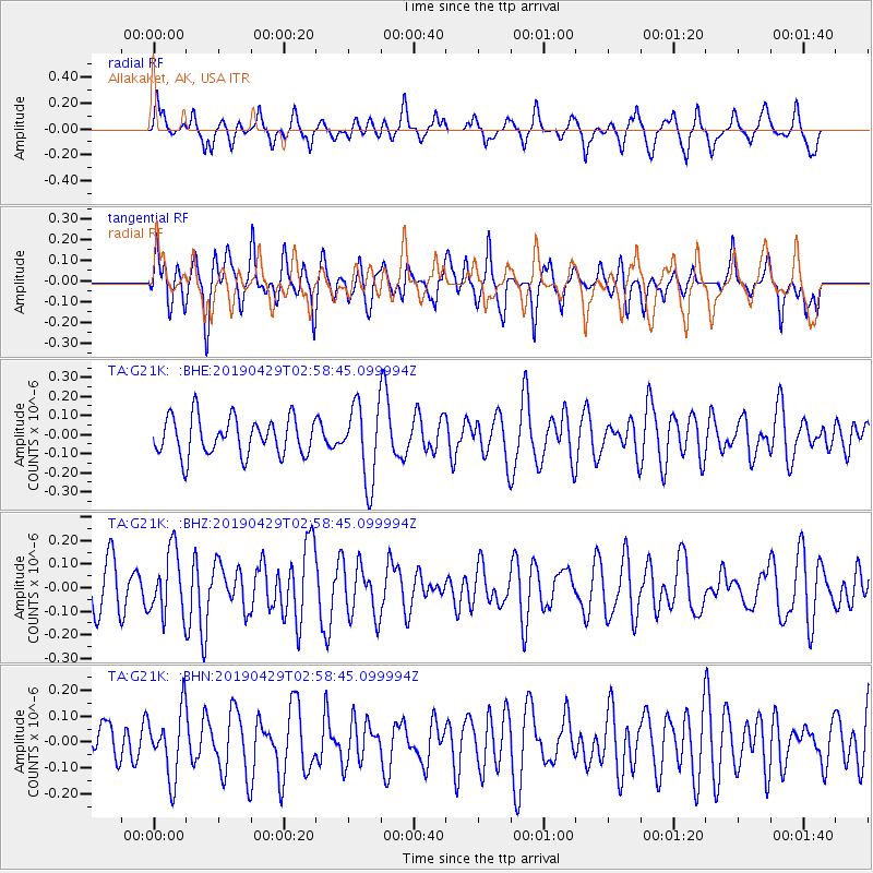
G21K Allakaket, AK, USA - Earthquake Result Viewer
*The percent match for this event was below the threshold and hence no stack was calculated.
| Earthquake location: |
Northern Mid-Atlantic Ridge |
| Earthquake latitude/longitude: |
43.2/-29.1 |
| Earthquake time(UTC): |
2019/04/29 (119) 02:48:51 GMT |
| Earthquake Depth: |
10 km |
| Earthquake Magnitude: |
5.5 Mww |
| Earthquake Catalog/Contributor: |
NEIC PDE/us |
|
| Network: |
TA USArray Transportable Network (new EarthScope stations) |
| Station: |
G21K Allakaket, AK, USA |
| Lat/Lon: |
66.52 N/153.51 W |
| Elevation: |
446 m |
|
| Distance: |
62.7 deg |
| Az: |
338.143 deg |
| Baz: |
42.81 deg |
| Ray Param: |
$rayparam |
*The percent match for this event was below the threshold and hence was not used in the summary stack. |
|
| Radial Match: |
47.027332 % |
| Radial Bump: |
388 |
| Transverse Match: |
42.754528 % |
| Transverse Bump: |
400 |
| SOD ConfigId: |
18252611 |
| Insert Time: |
2019-05-13 02:57:04.065 +0000 |
| GWidth: |
2.5 |
| Max Bumps: |
400 |
| Tol: |
0.001 |
|
Signal To Noise
| Channel | StoN | STA | LTA |
| TA:G21K: :BHZ:20190429T02:58:45.099994Z | 1.5183991 | 1.365638E-7 | 8.993933E-8 |
| TA:G21K: :BHN:20190429T02:58:45.099994Z | 1.4480038 | 1.2861105E-7 | 8.8819554E-8 |
| TA:G21K: :BHE:20190429T02:58:45.099994Z | 2.0302167 | 2.0064188E-7 | 9.882781E-8 |
| Arrivals |
| Ps | |
| PpPs | |
| PsPs/PpSs | |


