You are here: Home > Network List > TA - USArray Transportable Network (new EarthScope stations) Stations List
> Station L16A Fish Haven, ID, USA > Earthquake Result Viewer
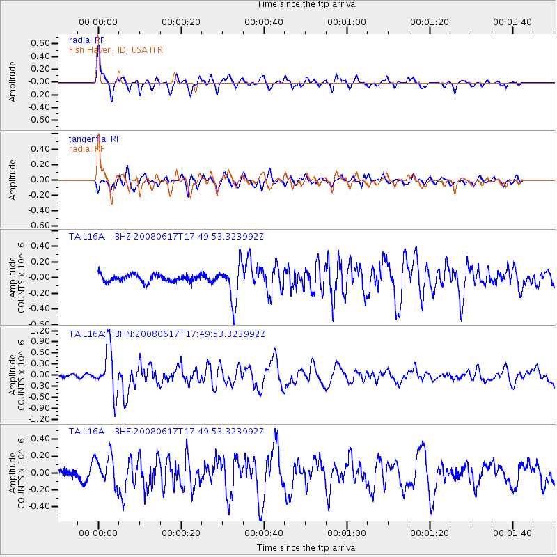
L16A Fish Haven, ID, USA - Earthquake Result Viewer
*The percent match for this event was below the threshold and hence no stack was calculated.
| Earthquake location: |
South Of Panama |
| Earthquake latitude/longitude: |
5.0/-82.7 |
| Earthquake time(UTC): |
2008/06/17 (169) 17:42:09 GMT |
| Earthquake Depth: |
10 km |
| Earthquake Magnitude: |
5.6 MB, 5.3 MS, 5.9 MW, 5.9 MW |
| Earthquake Catalog/Contributor: |
WHDF/NEIC |
|
| Network: |
TA USArray Transportable Network (new EarthScope stations) |
| Station: |
L16A Fish Haven, ID, USA |
| Lat/Lon: |
42.01 N/111.43 W |
| Elevation: |
2013 m |
|
| Distance: |
44.9 deg |
| Az: |
329.443 deg |
| Baz: |
137.183 deg |
| Ray Param: |
$rayparam |
*The percent match for this event was below the threshold and hence was not used in the summary stack. |
|
| Radial Match: |
76.48892 % |
| Radial Bump: |
371 |
| Transverse Match: |
70.81487 % |
| Transverse Bump: |
400 |
| SOD ConfigId: |
2504 |
| Insert Time: |
2010-03-06 21:52:08.676 +0000 |
| GWidth: |
2.5 |
| Max Bumps: |
400 |
| Tol: |
0.001 |
|
Signal To Noise
| Channel | StoN | STA | LTA |
| TA:L16A: :BHN:20080617T17:49:53.323992Z | 13.191083 | 6.3472686E-7 | 4.8117872E-8 |
| TA:L16A: :BHE:20080617T17:49:53.323992Z | 3.0372112 | 1.9079118E-7 | 6.281789E-8 |
| TA:L16A: :BHZ:20080617T17:49:53.323992Z | 5.5107102 | 2.4946013E-7 | 4.5268237E-8 |
| Arrivals |
| Ps | |
| PpPs | |
| PsPs/PpSs | |


