You are here: Home > Network List > TA - USArray Transportable Network (new EarthScope stations) Stations List
> Station N18A Larsen Ranch, Manila, UT, USA > Earthquake Result Viewer
N18A Larsen Ranch, Manila, UT, USA - Earthquake Result Viewer
| Earthquake location: |
Southern Peru |
| Earthquake latitude/longitude: |
-16.0/-71.7 |
| Earthquake time(UTC): |
2008/07/08 (190) 09:13:07 GMT |
| Earthquake Depth: |
123 km |
| Earthquake Magnitude: |
5.8 MB, 6.2 MW, 6.2 MW |
| Earthquake Catalog/Contributor: |
WHDF/NEIC |
|
| Network: |
TA USArray Transportable Network (new EarthScope stations) |
| Station: |
N18A Larsen Ranch, Manila, UT, USA |
| Lat/Lon: |
40.98 N/109.67 W |
| Elevation: |
1893 m |
|
| Distance: |
66.7 deg |
| Az: |
329.554 deg |
| Baz: |
139.933 deg |
| Ray Param: |
0.05711149 |
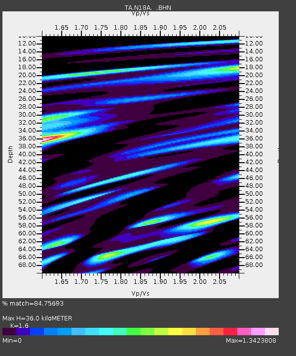
| Estimated Moho Depth: |
36.0 km |
| Estimated Crust Vp/Vs: |
1.60 |
| Assumed Crust Vp: |
6.207 km/s |
| Estimated Crust Vs: |
3.879 km/s |
| Estimated Crust Poisson's Ratio: |
0.18 |
|
| Radial Match: |
84.75693 % |
| Radial Bump: |
400 |
| Transverse Match: |
60.22693 % |
| Transverse Bump: |
400 |
| SOD ConfigId: |
2504 |
| Insert Time: |
2010-03-06 21:52:10.638 +0000 |
| GWidth: |
2.5 |
| Max Bumps: |
400 |
| Tol: |
0.001 |
|

Signal To Noise
| Channel | StoN | STA | LTA |
| TA:N18A: :BHN:20080708T09:23:14.374001Z | 8.132615 | 5.7129927E-7 | 7.0247914E-8 |
| TA:N18A: :BHE:20080708T09:23:14.374001Z | 2.490285 | 2.6402043E-7 | 1.0602017E-7 |
| TA:N18A: :BHZ:20080708T09:23:14.374001Z | 2.0401 | 2.1868024E-7 | 1.07190935E-7 |
| Arrivals |
| Ps | 3.6 SECOND |
| PpPs | 14 SECOND |
| PsPs/PpSs | 18 SECOND |


