You are here: Home > Network List > TA - USArray Transportable Network (new EarthScope stations) Stations List
> Station N18A Larsen Ranch, Manila, UT, USA > Earthquake Result Viewer
N18A Larsen Ranch, Manila, UT, USA - Earthquake Result Viewer
| Earthquake location: |
Central East Pacific Rise |
| Earthquake latitude/longitude: |
-9.0/-108.2 |
| Earthquake time(UTC): |
2008/10/30 (304) 15:15:41 GMT |
| Earthquake Depth: |
10 km |
| Earthquake Magnitude: |
5.5 MB, 5.8 MS, 6.0 MW, 6.0 MW |
| Earthquake Catalog/Contributor: |
WHDF/NEIC |
|
| Network: |
TA USArray Transportable Network (new EarthScope stations) |
| Station: |
N18A Larsen Ranch, Manila, UT, USA |
| Lat/Lon: |
40.98 N/109.67 W |
| Elevation: |
1893 m |
|
| Distance: |
49.8 deg |
| Az: |
358.585 deg |
| Baz: |
178.153 deg |
| Ray Param: |
0.06849322 |
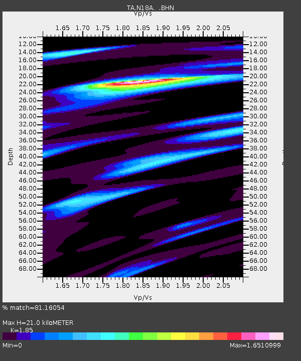
| Estimated Moho Depth: |
21.0 km |
| Estimated Crust Vp/Vs: |
1.85 |
| Assumed Crust Vp: |
6.207 km/s |
| Estimated Crust Vs: |
3.355 km/s |
| Estimated Crust Poisson's Ratio: |
0.29 |
|
| Radial Match: |
81.16054 % |
| Radial Bump: |
400 |
| Transverse Match: |
69.10992 % |
| Transverse Bump: |
400 |
| SOD ConfigId: |
2560 |
| Insert Time: |
2010-03-06 21:52:26.537 +0000 |
| GWidth: |
2.5 |
| Max Bumps: |
400 |
| Tol: |
0.001 |
|

Signal To Noise
| Channel | StoN | STA | LTA |
| TA:N18A: :BHN:20081030T15:24:02.724015Z | 2.4558716 | 3.27051E-7 | 1.3317106E-7 |
| TA:N18A: :BHE:20081030T15:24:02.724015Z | 2.2516046 | 2.8054794E-7 | 1.2459911E-7 |
| TA:N18A: :BHZ:20081030T15:24:02.724015Z | 1.0642425 | 1.18422705E-7 | 1.11274176E-7 |
| Arrivals |
| Ps | 3.0 SECOND |
| PpPs | 9.2 SECOND |
| PsPs/PpSs | 12 SECOND |


