You are here: Home > Network List > TA - USArray Transportable Network (new EarthScope stations) Stations List
> Station N18A Larsen Ranch, Manila, UT, USA > Earthquake Result Viewer
N18A Larsen Ranch, Manila, UT, USA - Earthquake Result Viewer
| Earthquake location: |
Peru-Ecuador Border Region |
| Earthquake latitude/longitude: |
-2.3/-77.8 |
| Earthquake time(UTC): |
2007/11/16 (320) 03:13:00 GMT |
| Earthquake Depth: |
123 km |
| Earthquake Magnitude: |
6.3 MB, 6.8 MW, 6.7 MW |
| Earthquake Catalog/Contributor: |
WHDF/NEIC |
|
| Network: |
TA USArray Transportable Network (new EarthScope stations) |
| Station: |
N18A Larsen Ranch, Manila, UT, USA |
| Lat/Lon: |
40.98 N/109.67 W |
| Elevation: |
1893 m |
|
| Distance: |
51.9 deg |
| Az: |
329.517 deg |
| Baz: |
137.976 deg |
| Ray Param: |
0.06668417 |
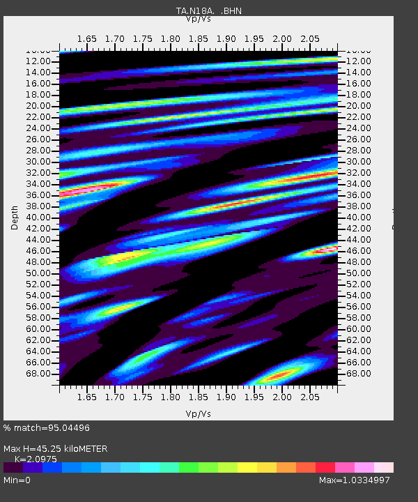
| Estimated Moho Depth: |
45.25 km |
| Estimated Crust Vp/Vs: |
2.10 |
| Assumed Crust Vp: |
6.207 km/s |
| Estimated Crust Vs: |
2.959 km/s |
| Estimated Crust Poisson's Ratio: |
0.35 |
|
| Radial Match: |
95.04496 % |
| Radial Bump: |
400 |
| Transverse Match: |
87.48336 % |
| Transverse Bump: |
400 |
| SOD ConfigId: |
2564 |
| Insert Time: |
2010-03-06 21:52:46.574 +0000 |
| GWidth: |
2.5 |
| Max Bumps: |
400 |
| Tol: |
0.001 |
|

Signal To Noise
| Channel | StoN | STA | LTA |
| TA:N18A: :BHN:20071116T03:21:25.798009Z | 4.429884 | 1.3188674E-6 | 2.977205E-7 |
| TA:N18A: :BHE:20071116T03:21:25.798009Z | 3.5133107 | 7.4062007E-7 | 2.1080403E-7 |
| TA:N18A: :BHZ:20071116T03:21:25.798009Z | 9.076687 | 2.3747896E-6 | 2.6163616E-7 |
| Arrivals |
| Ps | 8.4 SECOND |
| PpPs | 22 SECOND |
| PsPs/PpSs | 30 SECOND |


